Tårnby geodata
Tårnby (Capital Region) is a seat of a second-order administrative division; located in Denmark in Europe/Copenhagen (GMT+2) time zone. With population of 10,000 people, there are 75 cities with bigger population in this country. Compared to other cities in Denmark, 58.8% of cities are located further ↑North; 98.2% of cities are located further ←West and 98% of cities have higher elevation than Tårnby. Note1


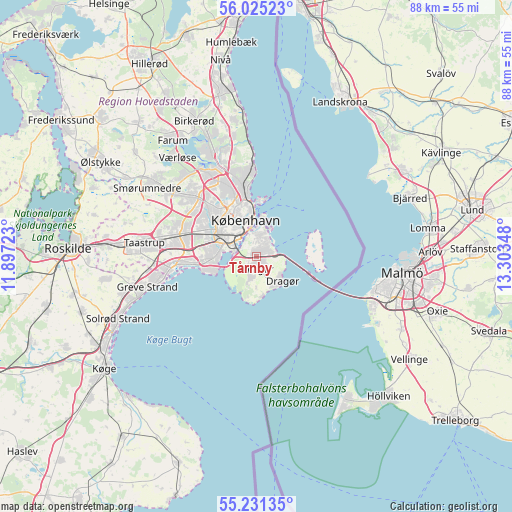
Tårnby GPS coordinates[2]
55° 37' 49.08" North, 12° 36' 1.26" East
| Map corner | latitude | longitude |
|---|---|---|
| Upper-left | 56.02523°, | 11.89723° |
| Center: | 55.6303°, | 12.60035° |
| Lower-right: | 55.23135°, | 13.30348° |
| Map W x H: | 88.3×88.3 km | = 54.9×54.9mi |
| max Lat: | 57.72093° ⇑58.8% North |
| Tårnby: | 55.6303° |
| min Lat: | ⇓41.2% South 54.57644° |
| min Long | Tårnby | max Long |
| 8.12605° | 12.60035° | 15.18662° |
| W 98.2%⇐ | ⇒1.8% E |
Elevation
Elevation of Tårnby is 2 m = 7 ft, and this is 25.3 m = 83 ft below average elevation for this country.
| Max E: |
114 m = 374 ft | 98% |
| Avg. | 27.3 m = 90 ft | |
| Tårnby | 2 m = 7 ft | |
Min E: |
0 m = 0 ft | 2% |
See also: Denmark elevation on elevation.city.
Geographical zone
Tårnby is located in North temperate zone (between Tropic of Cancer and the Arctic Circle). Distance of this North polar circle is 1215.7 km =755.4 mi to North.| Distance of | km | miles | from Tårnby |
|---|---|---|---|
| North Pole | 3821.6 | 2374.6 | to North |
| Arctic Circle | 1215.7 | 755.4 | to North |
| Tropic Cancer | 3579.6 | 2224.3 | to South |
| Equator | 6185.5 | 3843.5 | to South |


Nearby cities:
15 places around Tårnby: (largest is in red/bold)
• Albertslund
15.1 km =9.4 mi,  281°
281°
• Brøndbyvester
12.1 km =7.5 mi, 278°
• Buddinge
14.7 km =9.1 mi,  333°
333°
• Charlottenlund
13.7 km =8.5 mi,  353°
353°
• Christianshavn
4.8 km =3 mi,  356°
356°
• Copenhagen
5.5 km =3.4 mi,  336°
336°
• Dragør
6.1 km =3.8 mi,  132°
132°
• Frederiksberg
6.8 km =4.2 mi,  322°
322°
• Glostrup
13 km =8.1 mi,  288°
288°
• Herlev
14.5 km =9 mi, 315°
• Hvidovre
8.5 km =5.3 mi, 290°
• Rødovre
10.8 km =6.7 mi,  301°
301°
• Vallensbæk
13.5 km =8.4 mi,  266°
266°
• Vanløse
9.3 km =5.8 mi,  309°
309°
• Vibekevang
8.8 km =5.5 mi, 341°
Sources, notices
• [Note1] Compared only with cities in Denmark existing in our database
• [Src1] Map data: © OpenStreetMap contributors (CC-BY-SA)
• [Src2] Other city data from geonames.org with taken over terms of usage.
• [Src3] Geographical zone / Annual Mean Temperature by Robert A. Rohde @ Wikipedia
