Søften geodata
Søften (Central Jutland) is a populated place; located in Denmark in Europe/Copenhagen (GMT+2) time zone. With population of 2,030 people, there are 302 cities with bigger population in this country. Compared to other cities in Denmark, 77.5% of cities are located further ↓South; 57% of cities are located further →East and 74.6% of cities have lower elevation than Søften. Note1


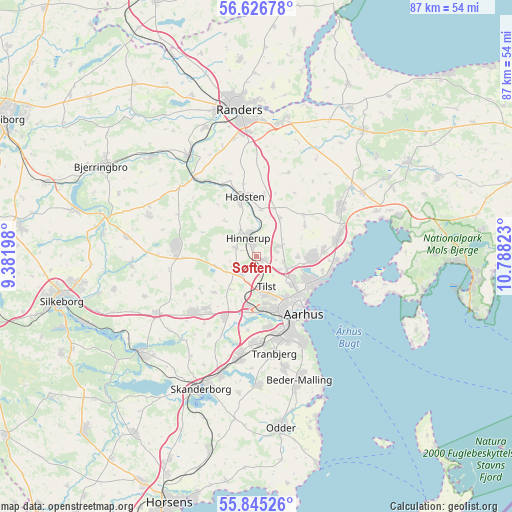
Søften GPS coordinates[2]
56° 14' 16.836" North, 10° 5' 6.36" East
| Map corner | latitude | longitude |
|---|---|---|
| Upper-left | 56.62678°, | 9.38198° |
| Center: | 56.23801°, | 10.0851° |
| Lower-right: | 55.84526°, | 10.78823° |
| Map W x H: | 86.9×86.9 km | = 54×54mi |
| max Lat: | 57.72093° ⇑22.5% North |
| Søften: | 56.23801° |
| min Lat: | ⇓77.5% South 54.57644° |
| min Long | Søften | max Long |
| 8.12605° | 10.0851° | 15.18662° |
| W 43%⇐ | ⇒57% E |
Elevation
Elevation of Søften is 41 m = 135 ft, and this is 13.7 m = 45 ft above average elevation for this country.
| Max E: |
114 m = 374 ft | 25.4% |
| Søften | 41 m 135 ft | |
| Avg. | 27.3 m = 90 ft | |
Min E: |
0 m = 0 ft | 74.6% |
See also: Denmark elevation on elevation.city.
Geographical zone
Søften is located in North temperate zone (between Tropic of Cancer and the Arctic Circle). Distance of this North polar circle is 1148.1 km =713.4 mi to North.| Distance of | km | miles | from Søften |
|---|---|---|---|
| North Pole | 3754 | 2332.6 | to North |
| Arctic Circle | 1148.1 | 713.4 | to North |
| Tropic Cancer | 3647.2 | 2266.3 | to South |
| Equator | 6253.1 | 3885.5 | to South |


Nearby cities:
15 places around Søften: (largest is in red/bold)
• Framlev
10.1 km =6.3 mi,  206°
206°
• Galten
13.6 km =8.5 mi,  229°
229°
• Hadsten
10.3 km =6.4 mi,  347°
347°
• Hammel
13.9 km =8.6 mi,  279°
279°
• Hinnerup
3.4 km =2.1 mi,  336°
336°
• Hjortshøj
11.2 km =7 mi,  84°
84°
• Kolt
14.4 km =8.9 mi,  183°
183°
• Lystrup
9.4 km =5.8 mi,  90°
90°
• Løgten
14.6 km =9.1 mi,  73°
73°
• Sabro
4.2 km =2.6 mi, 228°
• Skovby
12.5 km =7.8 mi,  223°
223°
• Stavtrup
12.1 km =7.5 mi,  169°
169°
• Tranbjerg
16.2 km =10.1 mi, 168°
• Trige
4.2 km =2.6 mi, 67°
• Århus
11.9 km =7.4 mi,  139°
139°
Sources, notices
• [Note1] Compared only with cities in Denmark existing in our database
• [Src1] Map data: © OpenStreetMap contributors (CC-BY-SA)
• [Src2] Other city data from geonames.org with taken over terms of usage.
• [Src3] Geographical zone / Annual Mean Temperature by Robert A. Rohde @ Wikipedia
