Løgten geodata
Løgten (Central Jutland) is a populated place; located in Denmark in Europe/Copenhagen (GMT+2) time zone. With population of 5,048 people, there are 130 cities with bigger population in this country. Compared to other cities in Denmark, 79.5% of cities are located further ↓South; 51.5% of cities are located further ←West and 96.2% of cities have lower elevation than Løgten. Note1


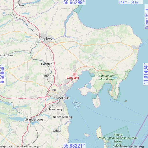
Løgten GPS coordinates[2]
56° 16' 28.524" North, 10° 18' 42.516" East
| Map corner | latitude | longitude |
|---|---|---|
| Upper-left | 56.66299°, | 9.60869° |
| Center: | 56.27459°, | 10.31181° |
| Lower-right: | 55.88221°, | 11.01494° |
| Map W x H: | 86.8×86.8 km | = 53.9×53.9mi |
| max Lat: | 57.72093° ⇑20.5% North |
| Løgten: | 56.27459° |
| min Lat: | ⇓79.5% South 54.57644° |
| min Long | Løgten | max Long |
| 8.12605° | 10.31181° | 15.18662° |
| W 51.5%⇐ | ⇒48.5% E |
Elevation
Elevation of Løgten is 69 m = 226 ft, and this is 41.7 m = 137 ft above average elevation for this country.
| Max E: |
114 m = 374 ft | 3.8% |
| Løgten | 69 m 226 ft | |
| Avg. | 27.3 m = 90 ft | |
Min E: |
0 m = 0 ft | 96.2% |
See also: Denmark elevation on elevation.city.
Geographical zone
Løgten is located in North temperate zone (between Tropic of Cancer and the Arctic Circle). Distance of this North polar circle is 1144 km =710.8 mi to North.| Distance of | km | miles | from Løgten |
|---|---|---|---|
| North Pole | 3749.9 | 2330.1 | to North |
| Arctic Circle | 1144 | 710.8 | to North |
| Tropic Cancer | 3651.2 | 2268.7 | to South |
| Equator | 6257.1 | 3888 | to South |


Nearby cities:
15 places around Løgten: (largest is in red/bold)
• Allingåbro
21.1 km =13.1 mi,  1°
1°
• Assentoft
21.1 km =13.1 mi,  332°
332°
• Auning
17.8 km =11.1 mi,  13°
13°
• Hadsten
17.3 km =10.7 mi,  290°
290°
• Hinnerup
15.4 km =9.6 mi,  266°
266°
• Hjortshøj
4.1 km =2.5 mi,  224°
224°
• Hornslet
4.6 km =2.9 mi, 6°
• Lystrup
6.2 km =3.9 mi,  227°
227°
• Ryomgård
17 km =10.6 mi,  44°
44°
• Rønde
10.5 km =6.5 mi,  73°
73°
• Sabro
18.4 km =11.4 mi,  248°
248°
• Stavtrup
19.9 km =12.4 mi, 216°
• Søften
14.6 km =9.1 mi, 253°
• Trige
10.4 km =6.5 mi,  256°
256°
• Århus
14.5 km =9 mi,  205°
205°
Sources, notices
• [Note1] Compared only with cities in Denmark existing in our database
• [Src1] Map data: © OpenStreetMap contributors (CC-BY-SA)
• [Src2] Other city data from geonames.org with taken over terms of usage.
• [Src3] Geographical zone / Annual Mean Temperature by Robert A. Rohde @ Wikipedia
