Hinnerup geodata
Hinnerup (Central Jutland) is a seat of a second-order administrative division; located in Denmark in Europe/Copenhagen (GMT+2) time zone. With population of 7,055 people, there are 105 cities with bigger population in this country. Compared to other cities in Denmark, 78.9% of cities are located further ↓South; 57.6% of cities are located further →East and 60.8% of cities have lower elevation than Hinnerup. Note1


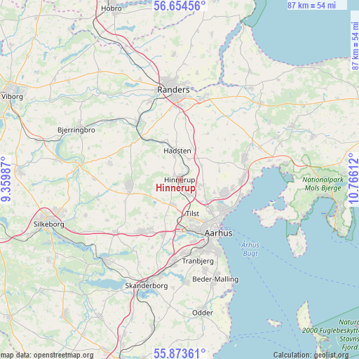
Hinnerup GPS coordinates[2]
56° 15' 57.888" North, 10° 3' 46.764" East
| Map corner | latitude | longitude |
|---|---|---|
| Upper-left | 56.65456°, | 9.35987° |
| Center: | 56.26608°, | 10.06299° |
| Lower-right: | 55.87361°, | 10.76612° |
| Map W x H: | 86.8×86.8 km | = 53.9×53.9mi |
| max Lat: | 57.72093° ⇑21.1% North |
| Hinnerup: | 56.26608° |
| min Lat: | ⇓78.9% South 54.57644° |
| min Long | Hinnerup | max Long |
| 8.12605° | 10.06299° | 15.18662° |
| W 42.4%⇐ | ⇒57.6% E |
Elevation
Elevation of Hinnerup is 30 m = 98 ft, and this is 2.7 m = 9 ft above average elevation for this country.
| Max E: |
114 m = 374 ft | 39.2% |
| Hinnerup | 30 m 98 ft | |
| Avg. | 27.3 m = 90 ft | |
Min E: |
0 m = 0 ft | 60.8% |
See also: Denmark elevation on elevation.city.
Geographical zone
Hinnerup is located in North temperate zone (between Tropic of Cancer and the Arctic Circle). Distance of this North polar circle is 1145 km =711.5 mi to North.| Distance of | km | miles | from Hinnerup |
|---|---|---|---|
| North Pole | 3750.9 | 2330.7 | to North |
| Arctic Circle | 1145 | 711.5 | to North |
| Tropic Cancer | 3650.3 | 2268.2 | to South |
| Equator | 6256.2 | 3887.4 | to South |


Nearby cities:
15 places around Hinnerup: (largest is in red/bold)
• Framlev
12.6 km =7.8 mi,  194°
194°
• Galten
14.9 km =9.3 mi,  217°
217°
• Hadsten
7 km =4.3 mi,  353°
353°
• Hammel
12.4 km =7.7 mi,  265°
265°
• Hjortshøj
12.7 km =7.9 mi,  99°
99°
• Hornslet
16.8 km =10.4 mi,  70°
70°
• Langå
17.3 km =10.7 mi,  323°
323°
• Lystrup
11.3 km =7 mi,  106°
106°
• Løgten
15.4 km =9.6 mi,  86°
86°
• Sabro
6.1 km =3.8 mi,  196°
196°
• Skovby
14.2 km =8.8 mi,  210°
210°
• Stavtrup
15.4 km =9.6 mi,  166°
166°
• Søften
3.4 km =2.1 mi,  156°
156°
• Trige
5.5 km =3.4 mi, 105°
• Århus
15.2 km =9.4 mi,  143°
143°
Sources, notices
• [Note1] Compared only with cities in Denmark existing in our database
• [Src1] Map data: © OpenStreetMap contributors (CC-BY-SA)
• [Src2] Other city data from geonames.org with taken over terms of usage.
• [Src3] Geographical zone / Annual Mean Temperature by Robert A. Rohde @ Wikipedia
