Hjortshøj geodata
Hjortshøj (Central Jutland) is a populated place; located in Denmark in Europe/Copenhagen (GMT+2) time zone. With population of 2,515 people, there are 249 cities with bigger population in this country. Compared to other cities in Denmark, 77.8% of cities are located further ↓South; 50.6% of cities are located further ←West and 83.6% of cities have lower elevation than Hjortshøj. Note1


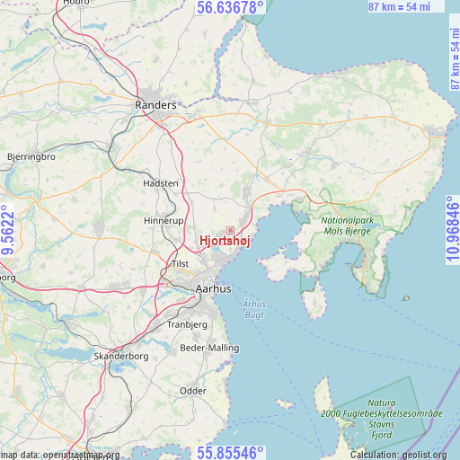
Hjortshøj GPS coordinates[2]
56° 14' 53.196" North, 10° 15' 55.188" East
| Map corner | latitude | longitude |
|---|---|---|
| Upper-left | 56.63678°, | 9.5622° |
| Center: | 56.24811°, | 10.26533° |
| Lower-right: | 55.85546°, | 10.96846° |
| Map W x H: | 86.9×86.9 km | = 54×54mi |
| max Lat: | 57.72093° ⇑22.2% North |
| Hjortshøj: | 56.24811° |
| min Lat: | ⇓77.8% South 54.57644° |
| min Long | Hjortshøj | max Long |
| 8.12605° | 10.26533° | 15.18662° |
| W 50.6%⇐ | ⇒49.4% E |
Elevation
Elevation of Hjortshøj is 50 m = 164 ft, and this is 22.7 m = 74 ft above average elevation for this country.
| Max E: |
114 m = 374 ft | 16.4% |
| Hjortshøj | 50 m 164 ft | |
| Avg. | 27.3 m = 90 ft | |
Min E: |
0 m = 0 ft | 83.6% |
See also: Denmark elevation on elevation.city.
Geographical zone
Hjortshøj is located in North temperate zone (between Tropic of Cancer and the Arctic Circle). Distance of this North polar circle is 1147 km =712.7 mi to North.| Distance of | km | miles | from Hjortshøj |
|---|---|---|---|
| North Pole | 3752.9 | 2331.9 | to North |
| Arctic Circle | 1147 | 712.7 | to North |
| Tropic Cancer | 3648.3 | 2266.9 | to South |
| Equator | 6254.2 | 3886.2 | to South |


Nearby cities:
15 places around Hjortshøj: (largest is in red/bold)
• Framlev
18.6 km =11.6 mi,  236°
236°
• Hadsten
16 km =9.9 mi,  303°
303°
• Hinnerup
12.7 km =7.9 mi,  279°
279°
• Hornslet
8.2 km =5.1 mi,  24°
24°
• Kolt
19.7 km =12.2 mi,  217°
217°
• Lystrup
2.1 km =1.3 mi, 235°
• Løgten
4.1 km =2.5 mi,  44°
44°
• Ryomgård
21.1 km =13.1 mi, 44°
• Rønde
14.2 km =8.8 mi,  65°
65°
• Sabro
14.8 km =9.2 mi,  254°
254°
• Stavtrup
15.8 km =9.8 mi,  214°
214°
• Søften
11.2 km =7 mi,  264°
264°
• Tranbjerg
18.8 km =11.7 mi, 205°
• Trige
7.2 km =4.5 mi,  274°
274°
• Århus
10.7 km =6.6 mi,  198°
198°
Sources, notices
• [Note1] Compared only with cities in Denmark existing in our database
• [Src1] Map data: © OpenStreetMap contributors (CC-BY-SA)
• [Src2] Other city data from geonames.org with taken over terms of usage.
• [Src3] Geographical zone / Annual Mean Temperature by Robert A. Rohde @ Wikipedia
