Måløv geodata
Måløv (Capital Region) is a populated place; located in Denmark in Europe/Copenhagen (GMT+2) time zone. With population of 8,513 people, there are 88 cities with bigger population in this country. Compared to other cities in Denmark, 52% of cities are located further ↓South; 87.4% of cities are located further ←West and 68.7% of cities have lower elevation than Måløv. Note1


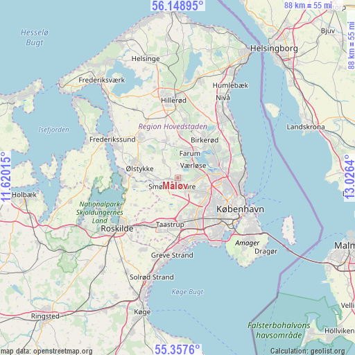
Måløv GPS coordinates[2]
55° 45' 19.008" North, 12° 19' 23.772" East
| Map corner | latitude | longitude |
|---|---|---|
| Upper-left | 56.14895°, | 11.62015° |
| Center: | 55.75528°, | 12.32327° |
| Lower-right: | 55.3576°, | 13.0264° |
| Map W x H: | 88×88 km | = 54.7×54.7mi |
| max Lat: | 57.72093° ⇑48% North |
| Måløv: | 55.75528° |
| min Lat: | ⇓52% South 54.57644° |
| min Long | Måløv | max Long |
| 8.12605° | 12.32327° | 15.18662° |
| W 87.4%⇐ | ⇒12.6% E |
Elevation
Elevation of Måløv is 36 m = 118 ft, and this is 8.7 m = 29 ft above average elevation for this country.
| Max E: |
114 m = 374 ft | 31.3% |
| Måløv | 36 m 118 ft | |
| Avg. | 27.3 m = 90 ft | |
Min E: |
0 m = 0 ft | 68.7% |
See also: Denmark elevation on elevation.city.
Geographical zone
Måløv is located in North temperate zone (between Tropic of Cancer and the Arctic Circle). Distance of this North polar circle is 1201.8 km =746.8 mi to North.| Distance of | km | miles | from Måløv |
|---|---|---|---|
| North Pole | 3807.7 | 2366 | to North |
| Arctic Circle | 1201.8 | 746.8 | to North |
| Tropic Cancer | 3593.5 | 2232.9 | to South |
| Equator | 6199.4 | 3852.1 | to South |


Nearby cities:
15 places around Måløv: (largest is in red/bold)
• Albertslund
11.2 km =7 mi,  166°
166°
• Ballerup
3.6 km =2.2 mi,  136°
136°
• Buddinge
10.8 km =6.7 mi,  94°
94°
• Farum
6.4 km =4 mi,  21°
21°
• Ganløse
5.4 km =3.4 mi,  317°
317°
• Glostrup
11.1 km =6.9 mi,  152°
152°
• Gundsømagle
11 km =6.8 mi,  258°
258°
• Herlev
8.1 km =5 mi,  115°
115°
• Holte
11.3 km =7 mi,  52°
52°
• Lynge
9.8 km =6.1 mi,  342°
342°
• Smørumnedre
1.9 km =1.2 mi,  221°
221°
• Stavnsholt
8.4 km =5.2 mi,  37°
37°
• Stenløse
8 km =5 mi,  280°
280°
• Veksø
5.3 km =3.3 mi,  269°
269°
• Værløse
4.1 km =2.5 mi, 43°
Sources, notices
• [Note1] Compared only with cities in Denmark existing in our database
• [Src1] Map data: © OpenStreetMap contributors (CC-BY-SA)
• [Src2] Other city data from geonames.org with taken over terms of usage.
• [Src3] Geographical zone / Annual Mean Temperature by Robert A. Rohde @ Wikipedia
