Stenløse geodata
Stenløse (Capital Region) is a seat of a second-order administrative division; located in Denmark in Europe/Copenhagen (GMT+2) time zone. With population of 19,998 people, there are 40 cities with bigger population in this country. Compared to other cities in Denmark, 53.2% of cities are located further ↓South; 83% of cities are located further ←West and 67% of cities have higher elevation than Stenløse. Note1


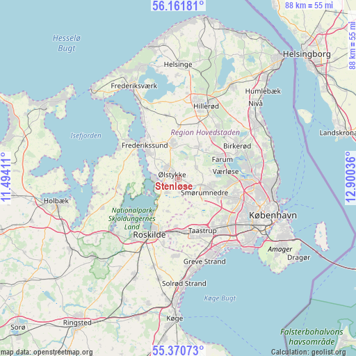
Stenløse GPS coordinates[2]
55° 46' 5.808" North, 12° 11' 50.028" East
| Map corner | latitude | longitude |
|---|---|---|
| Upper-left | 56.16181°, | 11.49411° |
| Center: | 55.76828°, | 12.19723° |
| Lower-right: | 55.37073°, | 12.90036° |
| Map W x H: | 88×88 km | = 54.7×54.7mi |
| max Lat: | 57.72093° ⇑46.8% North |
| Stenløse: | 55.76828° |
| min Lat: | ⇓53.2% South 54.57644° |
| min Long | Stenløse | max Long |
| 8.12605° | 12.19723° | 15.18662° |
| W 83%⇐ | ⇒17% E |
Elevation
Elevation of Stenløse is 14 m = 46 ft, and this is 13.3 m = 44 ft below average elevation for this country.
| Max E: |
114 m = 374 ft | 67% |
| Avg. | 27.3 m = 90 ft | |
| Stenløse | 14 m = 46 ft | |
Min E: |
0 m = 0 ft | 33% |
See also: Denmark elevation on elevation.city.
Geographical zone
Stenløse is located in North temperate zone (between Tropic of Cancer and the Arctic Circle). Distance of this North polar circle is 1200.3 km =745.8 mi to North.| Distance of | km | miles | from Stenløse |
|---|---|---|---|
| North Pole | 3806.2 | 2365.1 | to North |
| Arctic Circle | 1200.3 | 745.8 | to North |
| Tropic Cancer | 3594.9 | 2233.8 | to South |
| Equator | 6200.9 | 3853.1 | to South |


Nearby cities:
15 places around Stenløse: (largest is in red/bold)
• Ballerup
11.2 km =7 mi,  111°
111°
• Farum
11.2 km =7 mi,  66°
66°
• Fløng
11.8 km =7.3 mi,  183°
183°
• Frederikssund
11.3 km =7 mi,  314°
314°
• Ganløse
4.9 km =3 mi,  58°
58°
• Gundsømagle
4.6 km =2.9 mi,  218°
218°
• Jyllinge
6.1 km =3.8 mi,  253°
253°
• Lynge
9.4 km =5.8 mi,  32°
32°
• Måløv
8 km =5 mi,  100°
100°
• Slangerup
9.1 km =5.7 mi,  354°
354°
• Smørumnedre
7.2 km =4.5 mi, 113°
• Stavnsholt
14 km =8.7 mi, 68°
• Veksø
3 km =1.9 mi,  120°
120°
• Værløse
10.8 km =6.7 mi,  81°
81°
• Ølstykke
4 km =2.5 mi,  319°
319°
Sources, notices
• [Note1] Compared only with cities in Denmark existing in our database
• [Src1] Map data: © OpenStreetMap contributors (CC-BY-SA)
• [Src2] Other city data from geonames.org with taken over terms of usage.
• [Src3] Geographical zone / Annual Mean Temperature by Robert A. Rohde @ Wikipedia
