Kongens Lyngby geodata
Kongens Lyngby (Capital Region) is a seat of a second-order administrative division; located in Denmark in Europe/Copenhagen (GMT+2) time zone. With population of 10,600 people, there are 71 cities with bigger population in this country. Compared to other cities in Denmark, 53.8% of cities are located further ↓South; 95% of cities are located further ←West and 54.1% of cities have lower elevation than Kongens Lyngby. Note1


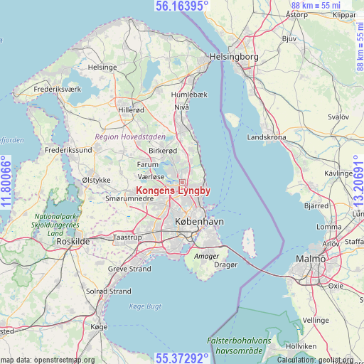
Kongens Lyngby GPS coordinates[2]
55° 46' 13.584" North, 12° 30' 13.608" East
| Map corner | latitude | longitude |
|---|---|---|
| Upper-left | 56.16395°, | 11.80066° |
| Center: | 55.77044°, | 12.50378° |
| Lower-right: | 55.37292°, | 13.20691° |
| Map W x H: | 88×88 km | = 54.7×54.7mi |
| max Lat: | 57.72093° ⇑46.2% North |
| Kongens Lyngby: | 55.77044° |
| min Lat: | ⇓53.8% South 54.57644° |
| min Long | Kongens Lyngby | max Long |
| 8.12605° | 12.50378° | 15.18662° |
| W 95%⇐ | ⇒5% E |
Elevation
Elevation of Kongens Lyngby is 25 m = 82 ft, and this is 2.3 m = 8 ft below average elevation for this country.
| Max E: |
114 m = 374 ft | 45.9% |
| Avg. | 27.3 m = 90 ft | |
| Kongens Lyngby | 25 m = 82 ft | |
Min E: |
0 m = 0 ft | 54.1% |
See also: Denmark elevation on elevation.city.
Geographical zone
Kongens Lyngby is located in North temperate zone (between Tropic of Cancer and the Arctic Circle). Distance of this North polar circle is 1200.1 km =745.7 mi to North.| Distance of | km | miles | from Kongens Lyngby |
|---|---|---|---|
| North Pole | 3806 | 2364.9 | to North |
| Arctic Circle | 1200.1 | 745.7 | to North |
| Tropic Cancer | 3595.2 | 2234 | to South |
| Equator | 6201.1 | 3853.2 | to South |


Nearby cities:
15 places around Kongens Lyngby: (largest is in red/bold)
• Ballerup
9.8 km =6.1 mi,  243°
243°
• Birkerød
9.8 km =6.1 mi,  331°
331°
• Buddinge
2.5 km =1.6 mi,  192°
192°
• Charlottenlund
4.9 km =3 mi,  114°
114°
• Copenhagen
11.2 km =7 mi,  159°
159°
• Farum
9.9 km =6.2 mi,  295°
295°
• Frederiksberg
10.3 km =6.4 mi,  169°
169°
• Herlev
6.6 km =4.1 mi,  217°
217°
• Holte
5.6 km =3.5 mi,  335°
335°
• Rødovre
10.5 km =6.5 mi,  197°
197°
• Stavnsholt
7.9 km =4.9 mi,  308°
308°
• Trørød
8.1 km =5 mi,  18°
18°
• Vanløse
9.7 km =6 mi, 186°
• Vibekevang
7.9 km =4.9 mi, 155°
• Værløse
8.6 km =5.3 mi,  279°
279°
Sources, notices
• [Note1] Compared only with cities in Denmark existing in our database
• [Src1] Map data: © OpenStreetMap contributors (CC-BY-SA)
• [Src2] Other city data from geonames.org with taken over terms of usage.
• [Src3] Geographical zone / Annual Mean Temperature by Robert A. Rohde @ Wikipedia
