Trørød geodata
Trørød (Capital Region) is a populated place; located in Denmark in Europe/Copenhagen (GMT+2) time zone. With population of 8,576 people, there are 86 cities with bigger population in this country. Compared to other cities in Denmark, 57% of cities are located further ↓South; 96.2% of cities are located further ←West and 50.9% of cities have higher elevation than Trørød. Note1


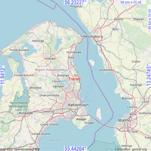
Trørød GPS coordinates[2]
55° 50' 22.056" North, 12° 32' 39.552" East
| Map corner | latitude | longitude |
|---|---|---|
| Upper-left | 56.23227°, | 11.8412° |
| Center: | 55.83946°, | 12.54432° |
| Lower-right: | 55.44264°, | 13.24745° |
| Map W x H: | 87.8×87.8 km | = 54.6×54.6mi |
| max Lat: | 57.72093° ⇑43% North |
| Trørød: | 55.83946° |
| min Lat: | ⇓57% South 54.57644° |
| min Long | Trørød | max Long |
| 8.12605° | 12.54432° | 15.18662° |
| W 96.2%⇐ | ⇒3.8% E |
Elevation
Elevation of Trørød is 21 m = 69 ft, and this is 6.3 m = 21 ft below average elevation for this country.
| Max E: |
114 m = 374 ft | 50.9% |
| Avg. | 27.3 m = 90 ft | |
| Trørød | 21 m = 69 ft | |
Min E: |
0 m = 0 ft | 49.1% |
See also: Denmark elevation on elevation.city.
Geographical zone
Trørød is located in North temperate zone (between Tropic of Cancer and the Arctic Circle). Distance of this North polar circle is 1192.4 km =740.9 mi to North.| Distance of | km | miles | from Trørød |
|---|---|---|---|
| North Pole | 3798.3 | 2360.2 | to North |
| Arctic Circle | 1192.4 | 740.9 | to North |
| Tropic Cancer | 3602.8 | 2238.7 | to South |
| Equator | 6208.8 | 3858 | to South |


Nearby cities:
15 places around Trørød: (largest is in red/bold)
• Birkerød
7.3 km =4.5 mi,  277°
277°
• Blovstrød
10.4 km =6.5 mi,  289°
289°
• Buddinge
10.6 km =6.6 mi,  196°
196°
• Charlottenlund
9.9 km =6.2 mi,  168°
168°
• Farum
12 km =7.5 mi,  253°
253°
• Herlev
14.4 km =8.9 mi,  206°
206°
• Holte
5.5 km =3.4 mi,  242°
242°
• Humlebæk
13.6 km =8.5 mi,  357°
357°
• Hørsholm
5.3 km =3.3 mi,  329°
329°
• Kokkedal
8.5 km =5.3 mi,  340°
340°
• Kongens Lyngby
8.1 km =5 mi, 198°
• Lillerød
13 km =8.1 mi, 287°
• Nivå
10.8 km =6.7 mi,  346°
346°
• Stavnsholt
9.1 km =5.7 mi, 252°
• Værløse
12.7 km =7.9 mi, 240°
Sources, notices
• [Note1] Compared only with cities in Denmark existing in our database
• [Src1] Map data: © OpenStreetMap contributors (CC-BY-SA)
• [Src2] Other city data from geonames.org with taken over terms of usage.
• [Src3] Geographical zone / Annual Mean Temperature by Robert A. Rohde @ Wikipedia
