Hundested geodata
Hundested (Capital Region) is a populated place; located in Denmark in Europe/Copenhagen (GMT+2) time zone. With population of 8,615 people, there are 85 cities with bigger population in this country. Compared to other cities in Denmark, 63.2% of cities are located further ↓South; 71.6% of cities are located further ←West and 89.8% of cities have higher elevation than Hundested. Note1


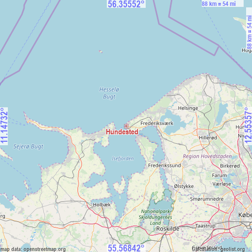
Hundested GPS coordinates[2]
55° 57' 50.292" North, 11° 51' 1.584" East
| Map corner | latitude | longitude |
|---|---|---|
| Upper-left | 56.35552°, | 11.14732° |
| Center: | 55.96397°, | 11.85044° |
| Lower-right: | 55.56842°, | 12.55357° |
| Map W x H: | 87.5×87.5 km | = 54.4×54.4mi |
| max Lat: | 57.72093° ⇑36.8% North |
| Hundested: | 55.96397° |
| min Lat: | ⇓63.2% South 54.57644° |
| min Long | Hundested | max Long |
| 8.12605° | 11.85044° | 15.18662° |
| W 71.6%⇐ | ⇒28.4% E |
Elevation
Elevation of Hundested is 5 m = 16 ft, and this is 22.3 m = 73 ft below average elevation for this country.
| Max E: |
114 m = 374 ft | 89.8% |
| Avg. | 27.3 m = 90 ft | |
| Hundested | 5 m = 16 ft | |
Min E: |
0 m = 0 ft | 10.2% |
See also: Denmark elevation on elevation.city.
Geographical zone
Hundested is located in North temperate zone (between Tropic of Cancer and the Arctic Circle). Distance of this North polar circle is 1178.6 km =732.3 mi to North.| Distance of | km | miles | from Hundested |
|---|---|---|---|
| North Pole | 3784.5 | 2351.6 | to North |
| Arctic Circle | 1178.6 | 732.3 | to North |
| Tropic Cancer | 3616.7 | 2247.3 | to South |
| Equator | 6222.6 | 3866.5 | to South |


Nearby cities:
15 places around Hundested: (largest is in red/bold)
• Asnæs
27.5 km =17.1 mi,  232°
232°
• Frederikssund
19.4 km =12.1 mi,  135°
135°
• Frederiksværk
10.7 km =6.6 mi,  85°
85°
• Helsinge
22.6 km =14 mi,  73°
73°
• Hillerød
28.3 km =17.6 mi,  98°
98°
• Holbæk
28.7 km =17.8 mi,  197°
197°
• Højby
16.8 km =10.4 mi,  249°
249°
• Jyllinge
28.3 km =17.6 mi,  146°
146°
• Jægerspris
15 km =9.3 mi, 145°
• Liseleje
9 km =5.6 mi,  52°
52°
• Nykøbing Sjælland
12 km =7.5 mi, 248°
• Skibby
24.6 km =15.3 mi,  163°
163°
• Skævinge
19.7 km =12.2 mi,  108°
108°
• Slangerup
24.3 km =15.1 mi,  121°
121°
• Ølstykke
26.7 km =16.6 mi,  134°
134°
Sources, notices
• [Note1] Compared only with cities in Denmark existing in our database
• [Src1] Map data: © OpenStreetMap contributors (CC-BY-SA)
• [Src2] Other city data from geonames.org with taken over terms of usage.
• [Src3] Geographical zone / Annual Mean Temperature by Robert A. Rohde @ Wikipedia
