Frederikssund geodata
Frederikssund (Capital Region) is a seat of a second-order administrative division; located in Denmark in Europe/Copenhagen (GMT+2) time zone. With population of 14,564 people, there are 52 cities with bigger population in this country. Compared to other cities in Denmark, 57.3% of cities are located further ↓South; 78.4% of cities are located further ←West and 56.1% of cities have higher elevation than Frederikssund. Note1


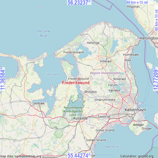
Frederikssund GPS coordinates[2]
55° 50' 22.416" North, 12° 4' 8.256" East
| Map corner | latitude | longitude |
|---|---|---|
| Upper-left | 56.23237°, | 11.36584° |
| Center: | 55.83956°, | 12.06896° |
| Lower-right: | 55.44274°, | 12.77209° |
| Map W x H: | 87.8×87.8 km | = 54.6×54.6mi |
| max Lat: | 57.72093° ⇑42.7% North |
| Frederikssund: | 55.83956° |
| min Lat: | ⇓57.3% South 54.57644° |
| min Long | Frederikssund | max Long |
| 8.12605° | 12.06896° | 15.18662° |
| W 78.4%⇐ | ⇒21.6% E |
Elevation
Elevation of Frederikssund is 17 m = 56 ft, and this is 10.3 m = 34 ft below average elevation for this country.
| Max E: |
114 m = 374 ft | 56.1% |
| Avg. | 27.3 m = 90 ft | |
| Frederikssund | 17 m = 56 ft | |
Min E: |
0 m = 0 ft | 43.9% |
See also: Denmark elevation on elevation.city.
Geographical zone
Frederikssund is located in North temperate zone (between Tropic of Cancer and the Arctic Circle). Distance of this North polar circle is 1192.4 km =740.9 mi to North.| Distance of | km | miles | from Frederikssund |
|---|---|---|---|
| North Pole | 3798.3 | 2360.2 | to North |
| Arctic Circle | 1192.4 | 740.9 | to North |
| Tropic Cancer | 3602.9 | 2238.7 | to South |
| Equator | 6208.8 | 3858 | to South |


Nearby cities:
15 places around Frederikssund: (largest is in red/bold)
• Frederiksværk
14.9 km =9.3 mi,  348°
348°
• Ganløse
13.3 km =8.3 mi,  113°
113°
• Gundsømagle
12.7 km =7.9 mi,  155°
155°
• Hillerød
17.5 km =10.9 mi,  55°
55°
• Jyllinge
9.9 km =6.2 mi,  167°
167°
• Jægerspris
5.4 km =3.4 mi,  285°
285°
• Lillerød
17.7 km =11 mi,  77°
77°
• Lynge
13 km =8.1 mi,  90°
90°
• Skibby
11.9 km =7.4 mi,  214°
214°
• Skævinge
9.1 km =5.7 mi,  33°
33°
• Slangerup
7.2 km =4.5 mi, 80°
• Smørumnedre
18.2 km =11.3 mi,  126°
126°
• Stenløse
11.3 km =7 mi, 134°
• Veksø
14.2 km =8.8 mi, 131°
• Ølstykke
7.3 km =4.5 mi, 132°
Sources, notices
• [Note1] Compared only with cities in Denmark existing in our database
• [Src1] Map data: © OpenStreetMap contributors (CC-BY-SA)
• [Src2] Other city data from geonames.org with taken over terms of usage.
• [Src3] Geographical zone / Annual Mean Temperature by Robert A. Rohde @ Wikipedia
