Jyllinge geodata
Jyllinge (Zealand) is a populated place; located in Denmark in Europe/Copenhagen (GMT+2) time zone. With population of 9,981 people, there are 76 cities with bigger population in this country. Compared to other cities in Denmark, 51.5% of cities are located further ↓South; 79.2% of cities are located further ←West and 52.6% of cities have lower elevation than Jyllinge. Note1


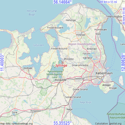
Jyllinge GPS coordinates[2]
55° 45' 10.62" North, 12° 6' 11.34" East
| Map corner | latitude | longitude |
|---|---|---|
| Upper-left | 56.14664°, | 11.40003° |
| Center: | 55.75295°, | 12.10315° |
| Lower-right: | 55.35525°, | 12.80628° |
| Map W x H: | 88×88 km | = 54.7×54.7mi |
| max Lat: | 57.72093° ⇑48.5% North |
| Jyllinge: | 55.75295° |
| min Lat: | ⇓51.5% South 54.57644° |
| min Long | Jyllinge | max Long |
| 8.12605° | 12.10315° | 15.18662° |
| W 79.2%⇐ | ⇒20.8% E |
Elevation
Elevation of Jyllinge is 24 m = 79 ft, and this is 3.3 m = 11 ft below average elevation for this country.
| Max E: |
114 m = 374 ft | 47.4% |
| Avg. | 27.3 m = 90 ft | |
| Jyllinge | 24 m = 79 ft | |
Min E: |
0 m = 0 ft | 52.6% |
See also: Denmark elevation on elevation.city.
Geographical zone
Jyllinge is located in North temperate zone (between Tropic of Cancer and the Arctic Circle). Distance of this North polar circle is 1202 km =746.9 mi to North.| Distance of | km | miles | from Jyllinge |
|---|---|---|---|
| North Pole | 3807.9 | 2366.1 | to North |
| Arctic Circle | 1202 | 746.9 | to North |
| Tropic Cancer | 3593.2 | 2232.7 | to South |
| Equator | 6199.1 | 3851.9 | to South |


Nearby cities:
15 places around Jyllinge: (largest is in red/bold)
• Fløng
11.4 km =7.1 mi,  152°
152°
• Frederikssund
9.9 km =6.2 mi,  347°
347°
• Ganløse
10.9 km =6.8 mi,  67°
67°
• Gundsømagle
3.6 km =2.2 mi,  122°
122°
• Jægerspris
13.3 km =8.3 mi,  326°
326°
• Lynge
14.5 km =9 mi,  48°
48°
• Måløv
13.8 km =8.6 mi,  88°
88°
• Roskilde
12.5 km =7.8 mi,  186°
186°
• Skibby
8.9 km =5.5 mi,  268°
268°
• Slangerup
11.9 km =7.4 mi,  24°
24°
• Smørumnedre
12.5 km =7.8 mi,  95°
95°
• Stenløse
6.1 km =3.8 mi, 73°
• Svogerslev
14.3 km =8.9 mi,  202°
202°
• Veksø
8.5 km =5.3 mi, 88°
• Ølstykke
5.8 km =3.6 mi,  34°
34°
Sources, notices
• [Note1] Compared only with cities in Denmark existing in our database
• [Src1] Map data: © OpenStreetMap contributors (CC-BY-SA)
• [Src2] Other city data from geonames.org with taken over terms of usage.
• [Src3] Geographical zone / Annual Mean Temperature by Robert A. Rohde @ Wikipedia
