Stoholm geodata
Stoholm (Central Jutland) is a populated place; located in Denmark in Europe/Copenhagen (GMT+2) time zone. With population of 2,202 people, there are 282 cities with bigger population in this country. Compared to other cities in Denmark, 84.8% of cities are located further ↓South; 86.5% of cities are located further →East and 50.9% of cities have lower elevation than Stoholm. Note1


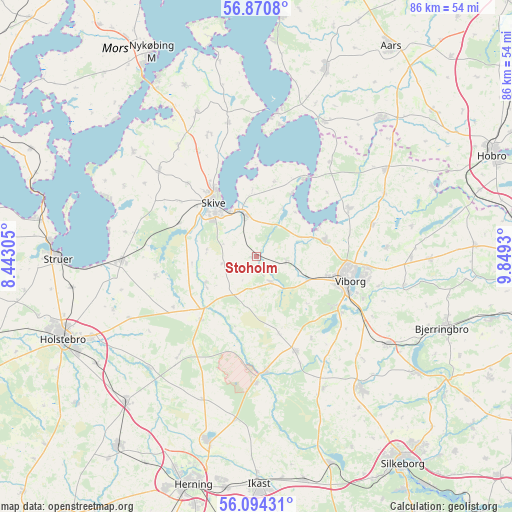
Stoholm GPS coordinates[2]
56° 29' 4.344" North, 9° 8' 46.212" East
| Map corner | latitude | longitude |
|---|---|---|
| Upper-left | 56.8708°, | 8.44305° |
| Center: | 56.48454°, | 9.14617° |
| Lower-right: | 56.09431°, | 9.8493° |
| Map W x H: | 86.3×86.3 km | = 53.6×53.6mi |
| max Lat: | 57.72093° ⇑15.2% North |
| Stoholm: | 56.48454° |
| min Lat: | ⇓84.8% South 54.57644° |
| min Long | Stoholm | max Long |
| 8.12605° | 9.14617° | 15.18662° |
| W 13.5%⇐ | ⇒86.5% E |
Elevation
Elevation of Stoholm is 23 m = 75 ft, and this is 4.3 m = 14 ft below average elevation for this country.
| Max E: |
114 m = 374 ft | 49.1% |
| Avg. | 27.3 m = 90 ft | |
| Stoholm | 23 m = 75 ft | |
Min E: |
0 m = 0 ft | 50.9% |
See also: Denmark elevation on elevation.city.
Geographical zone
Stoholm is located in North temperate zone (between Tropic of Cancer and the Arctic Circle). Distance of this North polar circle is 1120.7 km =696.4 mi to North.| Distance of | km | miles | from Stoholm |
|---|---|---|---|
| North Pole | 3726.6 | 2315.6 | to North |
| Arctic Circle | 1120.7 | 696.4 | to North |
| Tropic Cancer | 3674.6 | 2283.3 | to South |
| Equator | 6280.5 | 3902.5 | to South |


Nearby cities:
15 places around Stoholm: (largest is in red/bold)
• Avlum
32.7 km =20.3 mi,  221°
221°
• Bjerringbro
33.8 km =21 mi,  110°
110°
• Bording Kirkeby
35.6 km =22.1 mi,  170°
170°
• Farsø
34.2 km =21.3 mi,  20°
20°
• Gjellerup
38 km =23.6 mi,  188°
188°
• Holstebro
35.4 km =22 mi,  246°
246°
• Ikast
38.4 km =23.9 mi,  178°
178°
• Karup
19.8 km =12.3 mi, 176°
• Kjellerup
28.4 km =17.6 mi,  141°
141°
• Skive
11.7 km =7.3 mi,  321°
321°
• Struer
33.9 km =21.1 mi,  271°
271°
• Sunds
31.9 km =19.8 mi, 194°
• Viborg
16.1 km =10 mi,  102°
102°
• Vinderup
22.5 km =14 mi, 269°
• Ålestrup
31.6 km =19.6 mi,  42°
42°
Sources, notices
• [Note1] Compared only with cities in Denmark existing in our database
• [Src1] Map data: © OpenStreetMap contributors (CC-BY-SA)
• [Src2] Other city data from geonames.org with taken over terms of usage.
• [Src3] Geographical zone / Annual Mean Temperature by Robert A. Rohde @ Wikipedia
