Sunds geodata
Sunds (Central Jutland) is a populated place; located in Denmark in Europe/Copenhagen (GMT+2) time zone. With population of 3,525 people, there are 180 cities with bigger population in this country. Compared to other cities in Denmark, 76.6% of cities are located further ↓South; 89.8% of cities are located further →East and 76.9% of cities have lower elevation than Sunds. Note1


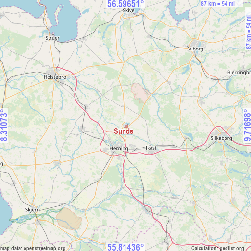
Sunds GPS coordinates[2]
56° 12' 26.748" North, 9° 0' 49.896" East
| Map corner | latitude | longitude |
|---|---|---|
| Upper-left | 56.59651°, | 8.31073° |
| Center: | 56.20743°, | 9.01386° |
| Lower-right: | 55.81436°, | 9.71698° |
| Map W x H: | 87×87 km | = 54.1×54.1mi |
| max Lat: | 57.72093° ⇑23.4% North |
| Sunds: | 56.20743° |
| min Lat: | ⇓76.6% South 54.57644° |
| min Long | Sunds | max Long |
| 8.12605° | 9.01386° | 15.18662° |
| W 10.2%⇐ | ⇒89.8% E |
Elevation
Elevation of Sunds is 43 m = 141 ft, and this is 15.7 m = 52 ft above average elevation for this country.
| Max E: |
114 m = 374 ft | 23.1% |
| Sunds | 43 m 141 ft | |
| Avg. | 27.3 m = 90 ft | |
Min E: |
0 m = 0 ft | 76.9% |
See also: Denmark elevation on elevation.city.
Geographical zone
Sunds is located in North temperate zone (between Tropic of Cancer and the Arctic Circle). Distance of this North polar circle is 1151.5 km =715.5 mi to North.| Distance of | km | miles | from Sunds |
|---|---|---|---|
| North Pole | 3757.4 | 2334.7 | to North |
| Arctic Circle | 1151.5 | 715.5 | to North |
| Tropic Cancer | 3643.8 | 2264.2 | to South |
| Equator | 6249.7 | 3883.4 | to South |


Nearby cities:
15 places around Sunds: (largest is in red/bold)
• Avlum
15.1 km =9.4 mi,  295°
295°
• Bording Kirkeby
14.9 km =9.3 mi,  106°
106°
• Gjellerup
7.3 km =4.5 mi,  159°
159°
• Hammerum
8.7 km =5.4 mi, 160°
• Herning
8.3 km =5.2 mi,  196°
196°
• Holstebro
29.8 km =18.5 mi, 304°
• Ikast
11.7 km =7.3 mi,  130°
130°
• Isenvad
16.9 km =10.5 mi,  135°
135°
• Karup
14.6 km =9.1 mi,  40°
40°
• Kibæk
21.8 km =13.5 mi,  206°
206°
• Kjellerup
27.5 km =17.1 mi,  71°
71°
• Lind
11.5 km =7.1 mi,  190°
190°
• Snejbjerg
10.7 km =6.6 mi,  219°
219°
• Videbæk
27.3 km =17 mi,  240°
240°
• Vildbjerg
15.3 km =9.5 mi,  266°
266°
Sources, notices
• [Note1] Compared only with cities in Denmark existing in our database
• [Src1] Map data: © OpenStreetMap contributors (CC-BY-SA)
• [Src2] Other city data from geonames.org with taken over terms of usage.
• [Src3] Geographical zone / Annual Mean Temperature by Robert A. Rohde @ Wikipedia
