Tårs geodata
Tårs (North Denmark) is a populated place; located in Denmark in Europe/Copenhagen (GMT+2) time zone. With population of 1,856 people, there are 318 cities with bigger population in this country. Compared to other cities in Denmark, 98.2% of cities are located further ↓South; 55.6% of cities are located further →East and 87.1% of cities have lower elevation than Tårs. Note1


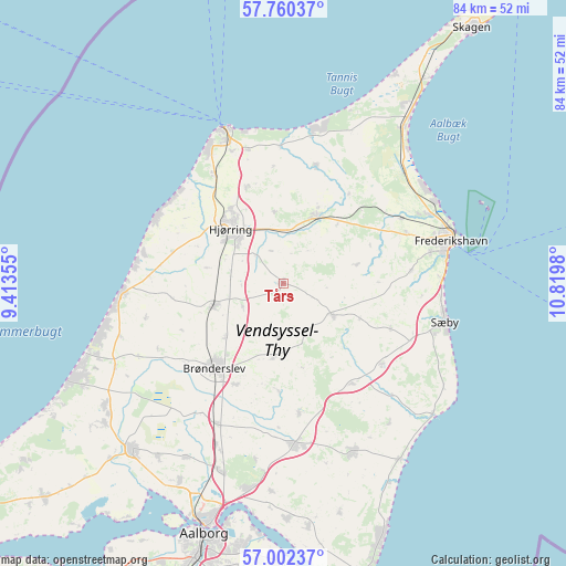
Tårs GPS coordinates[2]
57° 22' 59.988" North, 10° 7' 0.012" East
| Map corner | latitude | longitude |
|---|---|---|
| Upper-left | 57.76037°, | 9.41355° |
| Center: | 57.38333°, | 10.11667° |
| Lower-right: | 57.00237°, | 10.8198° |
| Map W x H: | 84.3×84.3 km | = 52.4×52.4mi |
| max Lat: | 57.72093° ⇑1.8% North |
| Tårs: | 57.38333° |
| min Lat: | ⇓98.2% South 54.57644° |
| min Long | Tårs | max Long |
| 8.12605° | 10.11667° | 15.18662° |
| W 44.4%⇐ | ⇒55.6% E |
Elevation
Elevation of Tårs is 54 m = 177 ft, and this is 26.7 m = 88 ft above average elevation for this country.
| Max E: |
114 m = 374 ft | 12.9% |
| Tårs | 54 m 177 ft | |
| Avg. | 27.3 m = 90 ft | |
Min E: |
0 m = 0 ft | 87.1% |
See also: Denmark elevation on elevation.city.
Geographical zone
Tårs is located in North temperate zone (between Tropic of Cancer and the Arctic Circle). Distance of this North polar circle is 1020.7 km =634.2 mi to North.| Distance of | km | miles | from Tårs |
|---|---|---|---|
| North Pole | 3626.6 | 2253.5 | to North |
| Arctic Circle | 1020.7 | 634.2 | to North |
| Tropic Cancer | 3774.5 | 2345.4 | to South |
| Equator | 6380.4 | 3964.6 | to South |


Nearby cities:
15 places around Tårs: (largest is in red/bold)
• Brønderslev
16.4 km =10.2 mi,  219°
219°
• Dronninglund
27 km =16.8 mi,  156°
156°
• Frederikshavn
25.9 km =16.1 mi,  75°
75°
• Hirtshals
24.6 km =15.3 mi,  337°
337°
• Hjallerup
24.4 km =15.2 mi,  175°
175°
• Hjørring
12.1 km =7.5 mi,  318°
318°
• Løkken
24.1 km =15 mi,  266°
266°
• Pandrup
32 km =19.9 mi,  235°
235°
• Sindal
11.1 km =6.9 mi,  27°
27°
• Strandby
25.7 km =16 mi,  62°
62°
• Sæby
25 km =15.5 mi,  103°
103°
• Vadum
33.4 km =20.8 mi,  207°
207°
• Vestbjerg
29.5 km =18.3 mi,  198°
198°
• Vodskov
31.1 km =19.3 mi,  190°
190°
• Vrå
11 km =6.8 mi,  252°
252°
Sources, notices
• [Note1] Compared only with cities in Denmark existing in our database
• [Src1] Map data: © OpenStreetMap contributors (CC-BY-SA)
• [Src2] Other city data from geonames.org with taken over terms of usage.
• [Src3] Geographical zone / Annual Mean Temperature by Robert A. Rohde @ Wikipedia
