Hadsund geodata
Hadsund (North Denmark) is a populated place; located in Denmark in Europe/Copenhagen (GMT+2) time zone. With population of 5,066 people, there are 128 cities with bigger population in this country. Compared to other cities in Denmark, 87.7% of cities are located further ↓South; 55.3% of cities are located further →East and 95.6% of cities have higher elevation than Hadsund. Note1


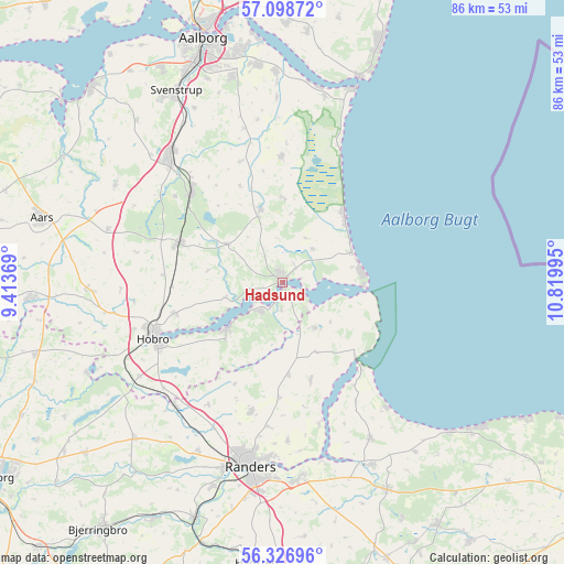
Hadsund GPS coordinates[2]
56° 42' 53.352" North, 10° 7' 0.552" East
| Map corner | latitude | longitude |
|---|---|---|
| Upper-left | 57.09872°, | 9.41369° |
| Center: | 56.71482°, | 10.11682° |
| Lower-right: | 56.32696°, | 10.81995° |
| Map W x H: | 85.8×85.8 km | = 53.3×53.3mi |
| max Lat: | 57.72093° ⇑12.3% North |
| Hadsund: | 56.71482° |
| min Lat: | ⇓87.7% South 54.57644° |
| min Long | Hadsund | max Long |
| 8.12605° | 10.11682° | 15.18662° |
| W 44.7%⇐ | ⇒55.3% E |
Elevation
Elevation of Hadsund is 3 m = 10 ft, and this is 24.3 m = 80 ft below average elevation for this country.
| Max E: |
114 m = 374 ft | 95.6% |
| Avg. | 27.3 m = 90 ft | |
| Hadsund | 3 m = 10 ft | |
Min E: |
0 m = 0 ft | 4.4% |
See also: Denmark elevation on elevation.city.
Geographical zone
Hadsund is located in North temperate zone (between Tropic of Cancer and the Arctic Circle). Distance of this North polar circle is 1095.1 km =680.5 mi to North.| Distance of | km | miles | from Hadsund |
|---|---|---|---|
| North Pole | 3701 | 2299.7 | to North |
| Arctic Circle | 1095.1 | 680.5 | to North |
| Tropic Cancer | 3700.2 | 2299.2 | to South |
| Equator | 6306.1 | 3918.4 | to South |


Nearby cities:
15 places around Hadsund: (largest is in red/bold)
• Allingåbro
30.5 km =19 mi,  155°
155°
• Arden
16.7 km =10.4 mi,  291°
291°
• Assentoft
30.4 km =18.9 mi,  175°
175°
• Auning
35.4 km =22 mi,  153°
153°
• Gistrup
32 km =19.9 mi,  346°
346°
• Hals
33.4 km =20.8 mi,  20°
20°
• Hobro
21.5 km =13.4 mi,  248°
248°
• Klarup
33.2 km =20.6 mi, 353°
• Mariager
11.3 km =7 mi,  230°
230°
• Randers
28.7 km =17.8 mi,  189°
189°
• Skørping
19.2 km =11.9 mi,  314°
314°
• Spentrup
20.3 km =12.6 mi, 193°
• Storvorde
32.2 km =20 mi,  358°
358°
• Støvring
25.4 km =15.8 mi,  318°
318°
• Svenstrup
33 km =20.5 mi,  330°
330°
Sources, notices
• [Note1] Compared only with cities in Denmark existing in our database
• [Src1] Map data: © OpenStreetMap contributors (CC-BY-SA)
• [Src2] Other city data from geonames.org with taken over terms of usage.
• [Src3] Geographical zone / Annual Mean Temperature by Robert A. Rohde @ Wikipedia
