Randers geodata
Randers (Central Jutland) is a seat of a second-order administrative division; located in Denmark in Europe/Copenhagen (GMT+2) time zone. With population of 55,780 people, there are 7 cities with bigger population in this country. Compared to other cities in Denmark, 83.9% of cities are located further ↓South; 59.4% of cities are located further →East and 71.9% of cities have higher elevation than Randers. Note1


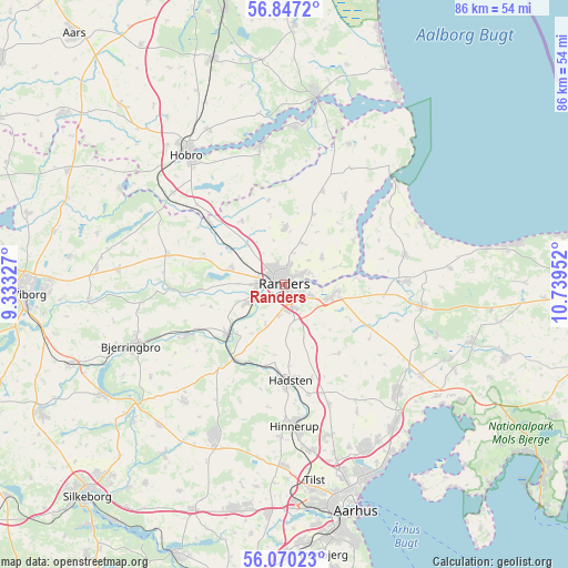
Randers GPS coordinates[2]
56° 27' 38.52" North, 10° 2' 11.004" East
| Map corner | latitude | longitude |
|---|---|---|
| Upper-left | 56.8472°, | 9.33327° |
| Center: | 56.4607°, | 10.03639° |
| Lower-right: | 56.07023°, | 10.73952° |
| Map W x H: | 86.4×86.4 km | = 53.7×53.7mi |
| max Lat: | 57.72093° ⇑16.1% North |
| Randers: | 56.4607° |
| min Lat: | ⇓83.9% South 54.57644° |
| min Long | Randers | max Long |
| 8.12605° | 10.03639° | 15.18662° |
| W 40.6%⇐ | ⇒59.4% E |
Elevation
Elevation of Randers is 12 m = 39 ft, and this is 15.3 m = 50 ft below average elevation for this country.
| Max E: |
114 m = 374 ft | 71.9% |
| Avg. | 27.3 m = 90 ft | |
| Randers | 12 m = 39 ft | |
Min E: |
0 m = 0 ft | 28.1% |
See also: Randers elevation on elevation.city.
Geographical zone
Randers is located in North temperate zone (between Tropic of Cancer and the Arctic Circle). Distance of this North polar circle is 1123.3 km =698 mi to North.| Distance of | km | miles | from Randers |
|---|---|---|---|
| North Pole | 3729.2 | 2317.2 | to North |
| Arctic Circle | 1123.3 | 698 | to North |
| Tropic Cancer | 3671.9 | 2281.6 | to South |
| Equator | 6277.8 | 3900.8 | to South |


Nearby cities:
15 places around Randers: (largest is in red/bold)
• Allingåbro
17.4 km =10.8 mi,  88°
88°
• Assentoft
7.4 km =4.6 mi,  106°
106°
• Auning
21.3 km =13.2 mi,  98°
98°
• Bjerringbro
24.9 km =15.5 mi,  248°
248°
• Hadsten
14.8 km =9.2 mi,  176°
176°
• Hammel
25 km =15.5 mi,  205°
205°
• Hinnerup
21.7 km =13.5 mi, 175°
• Hobro
25.3 km =15.7 mi,  323°
323°
• Hornslet
23.8 km =14.8 mi,  132°
132°
• Langå
11.7 km =7.3 mi,  228°
228°
• Mariager
21.4 km =13.3 mi,  349°
349°
• Spentrup
8.5 km =5.3 mi,  0°
0°
• Søften
24.9 km =15.5 mi,  173°
173°
• Trige
24.1 km =15 mi,  163°
163°
• Ulstrup
16.9 km =10.5 mi,  242°
242°
Sources, notices
• [Note1] Compared only with cities in Denmark existing in our database
• [Src1] Map data: © OpenStreetMap contributors (CC-BY-SA)
• [Src2] Other city data from geonames.org with taken over terms of usage.
• [Src3] Geographical zone / Annual Mean Temperature by Robert A. Rohde @ Wikipedia
