Arden geodata
Arden (North Denmark) is a populated place; located in Denmark in Europe/Copenhagen (GMT+2) time zone. With population of 2,516 people, there are 248 cities with bigger population in this country. Compared to other cities in Denmark, 88.3% of cities are located further ↓South; 67.8% of cities are located further →East and 96.5% of cities have lower elevation than Arden. Note1


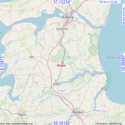
Arden GPS coordinates[2]
56° 46' 8.364" North, 9° 51' 42.624" East
| Map corner | latitude | longitude |
|---|---|---|
| Upper-left | 57.15234°, | 9.15872° |
| Center: | 56.76899°, | 9.86184° |
| Lower-right: | 56.38168°, | 10.56497° |
| Map W x H: | 85.7×85.7 km | = 53.3×53.3mi |
| max Lat: | 57.72093° ⇑11.7% North |
| Arden: | 56.76899° |
| min Lat: | ⇓88.3% South 54.57644° |
| min Long | Arden | max Long |
| 8.12605° | 9.86184° | 15.18662° |
| W 32.2%⇐ | ⇒67.8% E |
Elevation
Elevation of Arden is 73 m = 240 ft, and this is 45.7 m = 150 ft above average elevation for this country.
| Max E: |
114 m = 374 ft | 3.5% |
| Arden | 73 m 240 ft | |
| Avg. | 27.3 m = 90 ft | |
Min E: |
0 m = 0 ft | 96.5% |
See also: Denmark elevation on elevation.city.
Geographical zone
Arden is located in North temperate zone (between Tropic of Cancer and the Arctic Circle). Distance of this North polar circle is 1089.1 km =676.7 mi to North.| Distance of | km | miles | from Arden |
|---|---|---|---|
| North Pole | 3694.9 | 2295.9 | to North |
| Arctic Circle | 1089.1 | 676.7 | to North |
| Tropic Cancer | 3706.2 | 2302.9 | to South |
| Equator | 6312.1 | 3922.2 | to South |


Nearby cities:
15 places around Arden: (largest is in red/bold)
• Aalborg
31.2 km =19.4 mi,  6°
6°
• Aars
21.5 km =13.4 mi,  280°
280°
• Frejlev
26.5 km =16.5 mi,  354°
354°
• Gistrup
26.2 km =16.3 mi,  17°
17°
• Hadsund
16.7 km =10.4 mi,  111°
111°
• Hobro
14.7 km =9.1 mi,  197°
197°
• Klarup
29.5 km =18.3 mi, 23°
• Mariager
14.9 km =9.3 mi,  152°
152°
• Nibe
27.2 km =16.9 mi,  330°
330°
• Skørping
7.7 km =4.8 mi, 14°
• Spentrup
27.9 km =17.3 mi,  157°
157°
• Storvorde
29.9 km =18.6 mi,  29°
29°
• Støvring
13 km =8.1 mi, 353°
• Svenstrup
22.6 km =14 mi,  357°
357°
• Ålestrup
23.9 km =14.9 mi,  249°
249°
Sources, notices
• [Note1] Compared only with cities in Denmark existing in our database
• [Src1] Map data: © OpenStreetMap contributors (CC-BY-SA)
• [Src2] Other city data from geonames.org with taken over terms of usage.
• [Src3] Geographical zone / Annual Mean Temperature by Robert A. Rohde @ Wikipedia
