Auning geodata
Auning (Central Jutland) is a populated place; located in Denmark in Europe/Copenhagen (GMT+2) time zone. With population of 2,509 people, there are 252 cities with bigger population in this country. Compared to other cities in Denmark, 83% of cities are located further ↓South; 52.6% of cities are located further ←West and 74.3% of cities have higher elevation than Auning. Note1


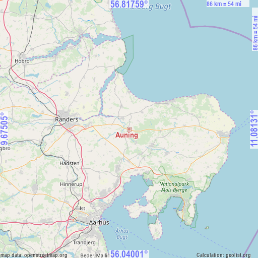
Auning GPS coordinates[2]
56° 25' 50.844" North, 10° 22' 41.448" East
| Map corner | latitude | longitude |
|---|---|---|
| Upper-left | 56.81759°, | 9.67505° |
| Center: | 56.43079°, | 10.37818° |
| Lower-right: | 56.04001°, | 11.08131° |
| Map W x H: | 86.5×86.5 km | = 53.7×53.7mi |
| max Lat: | 57.72093° ⇑17% North |
| Auning: | 56.43079° |
| min Lat: | ⇓83% South 54.57644° |
| min Long | Auning | max Long |
| 8.12605° | 10.37818° | 15.18662° |
| W 52.6%⇐ | ⇒47.4% E |
Elevation
Elevation of Auning is 11 m = 36 ft, and this is 16.3 m = 53 ft below average elevation for this country.
| Max E: |
114 m = 374 ft | 74.3% |
| Avg. | 27.3 m = 90 ft | |
| Auning | 11 m = 36 ft | |
Min E: |
0 m = 0 ft | 25.7% |
See also: Denmark elevation on elevation.city.
Geographical zone
Auning is located in North temperate zone (between Tropic of Cancer and the Arctic Circle). Distance of this North polar circle is 1126.7 km =700.1 mi to North.| Distance of | km | miles | from Auning |
|---|---|---|---|
| North Pole | 3732.5 | 2319.3 | to North |
| Arctic Circle | 1126.7 | 700.1 | to North |
| Tropic Cancer | 3668.6 | 2279.6 | to South |
| Equator | 6274.5 | 3898.8 | to South |


Nearby cities:
15 places around Auning: (largest is in red/bold)
• Allingåbro
5.2 km =3.2 mi,  315°
315°
• Assentoft
14 km =8.7 mi,  275°
275°
• Hadsten
23.2 km =14.4 mi,  240°
240°
• Hinnerup
26.7 km =16.6 mi,  226°
226°
• Hjortshøj
21.5 km =13.4 mi,  198°
198°
• Hornslet
13.3 km =8.3 mi, 195°
• Langå
30.1 km =18.7 mi,  261°
261°
• Lystrup
23.2 km =14.4 mi, 201°
• Løgten
17.8 km =11.1 mi,  193°
193°
• Randers
21.3 km =13.2 mi, 278°
• Ryomgård
9.3 km =5.8 mi,  123°
123°
• Rønde
15.6 km =9.7 mi,  157°
157°
• Spentrup
24 km =14.9 mi,  299°
299°
• Søften
28 km =17.4 mi,  220°
220°
• Trige
24.3 km =15.1 mi, 215°
Sources, notices
• [Note1] Compared only with cities in Denmark existing in our database
• [Src1] Map data: © OpenStreetMap contributors (CC-BY-SA)
• [Src2] Other city data from geonames.org with taken over terms of usage.
• [Src3] Geographical zone / Annual Mean Temperature by Robert A. Rohde @ Wikipedia
