Gilleleje geodata
Gilleleje (Capital Region) is a populated place; located in Denmark in Europe/Copenhagen (GMT+2) time zone. With population of 5,799 people, there are 117 cities with bigger population in this country. Compared to other cities in Denmark, 71.6% of cities are located further ↓South; 87.1% of cities are located further ←West and 67% of cities have higher elevation than Gilleleje. Note1


Gilleleje GPS coordinates[2]
56° 7' 19.056" North, 12° 18' 38.016" East
| Map corner | latitude | longitude |
|---|---|---|
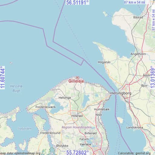
| Upper-left | 56.51191°, | 11.60744° |
| Center: | 56.12196°, | 12.31056° |
| Lower-right: | 55.72802°, | 13.01369° |
| Map W x H: | 87.2×87.2 km | = 54.2×54.2mi |
| max Lat: | 57.72093° ⇑28.4% North |
| Gilleleje: | 56.12196° |
| min Lat: | ⇓71.6% South 54.57644° |
| min Long | Gilleleje | max Long |
| 8.12605° | 12.31056° | 15.18662° |
| W 87.1%⇐ | ⇒12.9% E |
Elevation
Elevation of Gilleleje is 14 m = 46 ft, and this is 13.3 m = 44 ft below average elevation for this country.
| Max E: |
114 m = 374 ft | 67% |
| Avg. | 27.3 m = 90 ft | |
| Gilleleje | 14 m = 46 ft | |
Min E: |
0 m = 0 ft | 33% |
See also: Denmark elevation on elevation.city.
Geographical zone
Gilleleje is located in North temperate zone (between Tropic of Cancer and the Arctic Circle). Distance of this North polar circle is 1161 km =721.4 mi to North.| Distance of | km | miles | from Gilleleje |
|---|---|---|---|
| North Pole | 3766.9 | 2340.6 | to North |
| Arctic Circle | 1161 | 721.4 | to North |
| Tropic Cancer | 3634.3 | 2258.2 | to South |
| Equator | 6240.2 | 3877.5 | to South |


Nearby cities:
15 places around Gilleleje: (largest is in red/bold)
• Espergærde
20.4 km =12.7 mi,  133°
133°
• Fredensborg
17.3 km =10.7 mi,  160°
160°
• Frederiksværk
24.6 km =15.3 mi,  226°
226°
• Græsted
6.5 km =4 mi,  194°
194°
• Hellebæk
16.5 km =10.3 mi,  111°
111°
• Helsinge
13.1 km =8.1 mi,  212°
212°
• Helsingør
21.1 km =13.1 mi,  116°
116°
• Hillerød
21.6 km =13.4 mi,  181°
181°
• Hornbæk
9.7 km =6 mi, 111°
• Humlebæk
22.6 km =14 mi,  142°
142°
• Kokkedal
26.2 km =16.3 mi,  153°
153°
• Liseleje
24.6 km =15.3 mi,  240°
240°
• Nivå
24.1 km =15 mi, 149°
• Nødebo
16.1 km =10 mi,  171°
171°
• Skævinge
25.8 km =16 mi,  202°
202°
Sources, notices
• [Note1] Compared only with cities in Denmark existing in our database
• [Src1] Map data: © OpenStreetMap contributors (CC-BY-SA)
• [Src2] Other city data from geonames.org with taken over terms of usage.
• [Src3] Geographical zone / Annual Mean Temperature by Robert A. Rohde @ Wikipedia
