Hellebæk geodata
Hellebæk (Capital Region) is a populated place; located in Denmark in Europe/Copenhagen (GMT+2) time zone. With population of 5,243 people, there are 125 cities with bigger population in this country. Compared to other cities in Denmark, 68.7% of cities are located further ↓South; 97.1% of cities are located further ←West and 69.3% of cities have higher elevation than Hellebæk. Note1


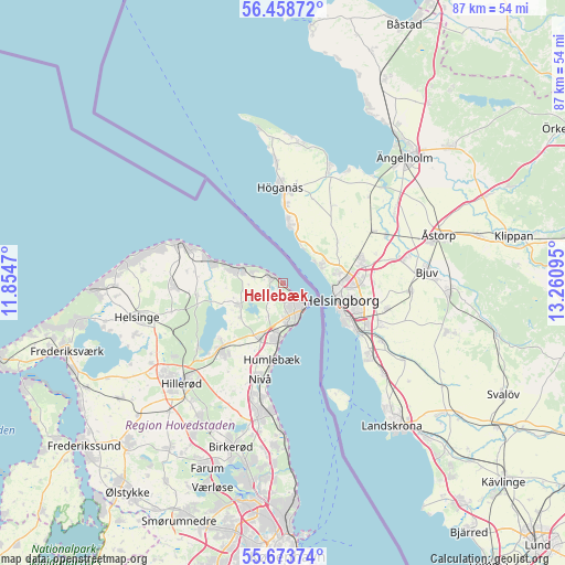
Hellebæk GPS coordinates[2]
56° 4' 5.628" North, 12° 33' 28.152" East
| Map corner | latitude | longitude |
|---|---|---|
| Upper-left | 56.45872°, | 11.8547° |
| Center: | 56.06823°, | 12.55782° |
| Lower-right: | 55.67374°, | 13.26095° |
| Map W x H: | 87.3×87.3 km | = 54.2×54.2mi |
| max Lat: | 57.72093° ⇑31.3% North |
| Hellebæk: | 56.06823° |
| min Lat: | ⇓68.7% South 54.57644° |
| min Long | Hellebæk | max Long |
| 8.12605° | 12.55782° | 15.18662° |
| W 97.1%⇐ | ⇒2.9% E |
Elevation
Elevation of Hellebæk is 13 m = 43 ft, and this is 14.3 m = 47 ft below average elevation for this country.
| Max E: |
114 m = 374 ft | 69.3% |
| Avg. | 27.3 m = 90 ft | |
| Hellebæk | 13 m = 43 ft | |
Min E: |
0 m = 0 ft | 30.7% |
See also: Denmark elevation on elevation.city.
Geographical zone
Hellebæk is located in North temperate zone (between Tropic of Cancer and the Arctic Circle). Distance of this North polar circle is 1167 km =725.1 mi to North.| Distance of | km | miles | from Hellebæk |
|---|---|---|---|
| North Pole | 3772.9 | 2344.4 | to North |
| Arctic Circle | 1167 | 725.1 | to North |
| Tropic Cancer | 3628.3 | 2254.5 | to South |
| Equator | 6234.2 | 3873.8 | to South |


Nearby cities:
15 places around Hellebæk: (largest is in red/bold)
• Blovstrød
24.4 km =15.2 mi,  205°
205°
• Espergærde
8.2 km =5.1 mi,  184°
184°
• Fredensborg
14.1 km =8.8 mi,  223°
223°
• Gilleleje
16.5 km =10.3 mi,  291°
291°
• Græsted
16.9 km =10.5 mi,  269°
269°
• Helsinge
22.9 km =14.2 mi,  257°
257°
• Helsingør
5 km =3.1 mi,  135°
135°
• Hillerød
22.3 km =13.9 mi,  225°
225°
• Hornbæk
6.7 km =4.2 mi, 291°
• Humlebæk
11.9 km =7.4 mi,  187°
187°
• Hørsholm
21.1 km =13.1 mi, 189°
• Kokkedal
17.8 km =11.1 mi, 191°
• Lillerød
25.2 km =15.7 mi, 211°
• Nivå
15.3 km =9.5 mi, 192°
• Nødebo
16.5 km =10.3 mi, 232°
Sources, notices
• [Note1] Compared only with cities in Denmark existing in our database
• [Src1] Map data: © OpenStreetMap contributors (CC-BY-SA)
• [Src2] Other city data from geonames.org with taken over terms of usage.
• [Src3] Geographical zone / Annual Mean Temperature by Robert A. Rohde @ Wikipedia
