Fløng geodata
Fløng (Capital Region) is a populated place; located in Denmark in Europe/Copenhagen (GMT+2) time zone. With population of 11,108 people, there are 67 cities with bigger population in this country. Compared to other cities in Denmark, 56.1% of cities are located further ↑North; 82.7% of cities are located further ←West and 57.3% of cities have lower elevation than Fløng. Note1


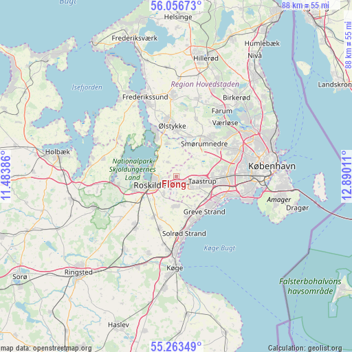
Fløng GPS coordinates[2]
55° 39' 43.632" North, 12° 11' 13.128" East
| Map corner | latitude | longitude |
|---|---|---|
| Upper-left | 56.05673°, | 11.48386° |
| Center: | 55.66212°, | 12.18698° |
| Lower-right: | 55.26349°, | 12.89011° |
| Map W x H: | 88.2×88.2 km | = 54.8×54.8mi |
| max Lat: | 57.72093° ⇑56.1% North |
| Fløng: | 55.66212° |
| min Lat: | ⇓43.9% South 54.57644° |
| min Long | Fløng | max Long |
| 8.12605° | 12.18698° | 15.18662° |
| W 82.7%⇐ | ⇒17.3% E |
Elevation
Elevation of Fløng is 27 m = 89 ft, and this is 0.3 m = 1 ft below average elevation for this country.
| Max E: |
114 m = 374 ft | 42.7% |
| Avg. | 27.3 m = 90 ft | |
| Fløng | 27 m = 89 ft | |
Min E: |
0 m = 0 ft | 57.3% |
See also: Denmark elevation on elevation.city.
Geographical zone
Fløng is located in North temperate zone (between Tropic of Cancer and the Arctic Circle). Distance of this North polar circle is 1212.1 km =753.2 mi to North.| Distance of | km | miles | from Fløng |
|---|---|---|---|
| North Pole | 3818 | 2372.4 | to North |
| Arctic Circle | 1212.1 | 753.2 | to North |
| Tropic Cancer | 3583.1 | 2226.4 | to South |
| Equator | 6189 | 3845.7 | to South |


Nearby cities:
15 places around Fløng: (largest is in red/bold)
• Albertslund
11.1 km =6.9 mi,  92°
92°
• Greve
11.3 km =7 mi,  140°
140°
• Gundsømagle
8.5 km =5.3 mi,  344°
344°
• Ishøj
11.6 km =7.2 mi,  116°
116°
• Jyllinge
11.4 km =7.1 mi,  332°
332°
• Måløv
13.4 km =8.3 mi,  39°
39°
• Roskilde
7.1 km =4.4 mi,  251°
251°
• Smørumnedre
11.5 km =7.1 mi, 39°
• Stenløse
11.8 km =7.3 mi,  3°
3°
• Svogerslev
11.2 km =7 mi, 253°
• Taastrup
7.3 km =4.5 mi,  100°
100°
• Tune
7.8 km =4.8 mi,  188°
188°
• Vallensbæk
13.2 km =8.2 mi,  109°
109°
• Veksø
10.8 km =6.7 mi,  17°
17°
• Vindinge
5.3 km =3.3 mi,  214°
214°
Sources, notices
• [Note1] Compared only with cities in Denmark existing in our database
• [Src1] Map data: © OpenStreetMap contributors (CC-BY-SA)
• [Src2] Other city data from geonames.org with taken over terms of usage.
• [Src3] Geographical zone / Annual Mean Temperature by Robert A. Rohde @ Wikipedia
