Fensmark geodata
Fensmark (Zealand) is a populated place; located in Denmark in Europe/Copenhagen (GMT+2) time zone. With population of 4,203 people, there are 154 cities with bigger population in this country. Compared to other cities in Denmark, 82.7% of cities are located further ↑North; 70.8% of cities are located further ←West and 94.7% of cities have lower elevation than Fensmark. Note1


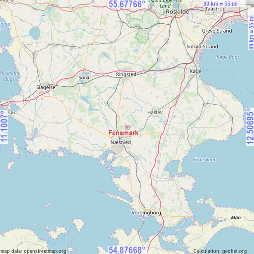
Fensmark GPS coordinates[2]
55° 16' 45.084" North, 11° 48' 13.752" East
| Map corner | latitude | longitude |
|---|---|---|
| Upper-left | 55.67766°, | 11.1007° |
| Center: | 55.27919°, | 11.80382° |
| Lower-right: | 54.87668°, | 12.50695° |
| Map W x H: | 89.1×89.1 km | = 55.4×55.4mi |
| max Lat: | 57.72093° ⇑82.7% North |
| Fensmark: | 55.27919° |
| min Lat: | ⇓17.3% South 54.57644° |
| min Long | Fensmark | max Long |
| 8.12605° | 11.80382° | 15.18662° |
| W 70.8%⇐ | ⇒29.2% E |
Elevation
Elevation of Fensmark is 67 m = 220 ft, and this is 39.7 m = 130 ft above average elevation for this country.
| Max E: |
114 m = 374 ft | 5.3% |
| Fensmark | 67 m 220 ft | |
| Avg. | 27.3 m = 90 ft | |
Min E: |
0 m = 0 ft | 94.7% |
See also: Denmark elevation on elevation.city.
Geographical zone
Fensmark is located in North temperate zone (between Tropic of Cancer and the Arctic Circle). Distance of this North polar circle is 1254.7 km =779.6 mi to North.| Distance of | km | miles | from Fensmark |
|---|---|---|---|
| North Pole | 3860.6 | 2398.9 | to North |
| Arctic Circle | 1254.7 | 779.6 | to North |
| Tropic Cancer | 3540.6 | 2200 | to South |
| Equator | 6146.5 | 3819.3 | to South |


Nearby cities:
15 places around Fensmark: (largest is in red/bold)
• Bjæverskov
24.7 km =15.3 mi,  36°
36°
• Borup
26.3 km =16.3 mi,  24°
24°
• Faxe
20.2 km =12.6 mi,  97°
97°
• Faxe Ladeplads
24.1 km =15 mi,  105°
105°
• Frederiksberg
21.3 km =13.2 mi,  315°
315°
• Fuglebjerg
16.5 km =10.3 mi,  280°
280°
• Haslev
11.3 km =7 mi,  64°
64°
• Hårlev
28.3 km =17.6 mi,  73°
73°
• Neder Vindinge
27.9 km =17.3 mi,  169°
169°
• Næstved
6.1 km =3.8 mi,  206°
206°
• Præstø
23.1 km =14.4 mi,  138°
138°
• Ringsted
18.2 km =11.3 mi,  357°
357°
• Rønnede
14 km =8.7 mi, 100°
• Sorø
23.1 km =14.4 mi, 317°
• Ørslev
28.2 km =17.5 mi,  158°
158°
Sources, notices
• [Note1] Compared only with cities in Denmark existing in our database
• [Src1] Map data: © OpenStreetMap contributors (CC-BY-SA)
• [Src2] Other city data from geonames.org with taken over terms of usage.
• [Src3] Geographical zone / Annual Mean Temperature by Robert A. Rohde @ Wikipedia
