Sorø geodata
Sorø (Zealand) is a seat of a first-order administrative division; located in Denmark in Europe/Copenhagen (GMT+2) time zone. With population of 7,167 people, there are 103 cities with bigger population in this country. Compared to other cities in Denmark, 73.7% of cities are located further ↑North; 67.5% of cities are located further ←West and 76.9% of cities have lower elevation than Sorø. Note1


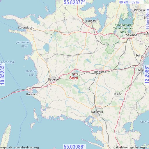
Sorø GPS coordinates[2]
55° 25' 54.624" North, 11° 33' 19.692" East
| Map corner | latitude | longitude |
|---|---|---|
| Upper-left | 55.82877°, | 10.85235° |
| Center: | 55.43184°, | 11.55547° |
| Lower-right: | 55.03088°, | 12.2586° |
| Map W x H: | 88.7×88.7 km | = 55.1×55.1mi |
| max Lat: | 57.72093° ⇑73.7% North |
| Sorø: | 55.43184° |
| min Lat: | ⇓26.3% South 54.57644° |
| min Long | Sorø | max Long |
| 8.12605° | 11.55547° | 15.18662° |
| W 67.5%⇐ | ⇒32.5% E |
Elevation
Elevation of Sorø is 43 m = 141 ft, and this is 15.7 m = 52 ft above average elevation for this country.
| Max E: |
114 m = 374 ft | 23.1% |
| Sorø | 43 m 141 ft | |
| Avg. | 27.3 m = 90 ft | |
Min E: |
0 m = 0 ft | 76.9% |
See also: Denmark elevation on elevation.city.
Geographical zone
Sorø is located in North temperate zone (between Tropic of Cancer and the Arctic Circle). Distance of this North polar circle is 1237.7 km =769.1 mi to North.| Distance of | km | miles | from Sorø |
|---|---|---|---|
| North Pole | 3843.6 | 2388.3 | to North |
| Arctic Circle | 1237.7 | 769.1 | to North |
| Tropic Cancer | 3557.5 | 2210.5 | to South |
| Equator | 6163.4 | 3829.8 | to South |


Nearby cities:
15 places around Sorø: (largest is in red/bold)
• Dianalund
11.8 km =7.3 mi,  340°
340°
• Fensmark
23.1 km =14.4 mi,  137°
137°
• Forlev
19.7 km =12.2 mi,  251°
251°
• Frederiksberg
1.9 km =1.2 mi,  153°
153°
• Fuglebjerg
14 km =8.7 mi,  182°
182°
• Gørlev
23.9 km =14.9 mi,  299°
299°
• Høng
18.8 km =11.7 mi, 296°
• Jyderup
27.2 km =16.9 mi, 341°
• Kirke Hvalsø
26.3 km =16.3 mi,  47°
47°
• Næstved
25.9 km =16.1 mi, 149°
• Ringsted
14.8 km =9.2 mi,  85°
85°
• Skælskør
26.1 km =16.2 mi,  219°
219°
• Slagelse
13.1 km =8.1 mi,  255°
255°
• Stenlille
12.1 km =7.5 mi,  10°
10°
• Tølløse
24.2 km =15 mi,  33°
33°
Sources, notices
• [Note1] Compared only with cities in Denmark existing in our database
• [Src1] Map data: © OpenStreetMap contributors (CC-BY-SA)
• [Src2] Other city data from geonames.org with taken over terms of usage.
• [Src3] Geographical zone / Annual Mean Temperature by Robert A. Rohde @ Wikipedia
