Ålestrup geodata
Ålestrup (North Denmark) is a populated place; located in Denmark in Europe/Copenhagen (GMT+2) time zone. With population of 2,787 people, there are 228 cities with bigger population in this country. Compared to other cities in Denmark, 87.1% of cities are located further ↓South; 78.9% of cities are located further →East and 55.8% of cities have lower elevation than Ålestrup. Note1


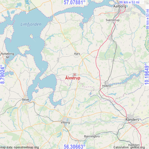
Ålestrup GPS coordinates[2]
56° 41' 40.92" North, 9° 29' 36.096" East
| Map corner | latitude | longitude |
|---|---|---|
| Upper-left | 57.07881°, | 8.79024° |
| Center: | 56.6947°, | 9.49336° |
| Lower-right: | 56.30663°, | 10.19649° |
| Map W x H: | 85.9×85.9 km | = 53.4×53.4mi |
| max Lat: | 57.72093° ⇑12.9% North |
| Ålestrup: | 56.6947° |
| min Lat: | ⇓87.1% South 54.57644° |
| min Long | Ålestrup | max Long |
| 8.12605° | 9.49336° | 15.18662° |
| W 21.1%⇐ | ⇒78.9% E |
Elevation
Elevation of Ålestrup is 26 m = 85 ft, and this is 1.3 m = 4 ft below average elevation for this country.
| Max E: |
114 m = 374 ft | 44.2% |
| Avg. | 27.3 m = 90 ft | |
| Ålestrup | 26 m = 85 ft | |
Min E: |
0 m = 0 ft | 55.8% |
See also: Denmark elevation on elevation.city.
Geographical zone
Ålestrup is located in North temperate zone (between Tropic of Cancer and the Arctic Circle). Distance of this North polar circle is 1097.3 km =681.8 mi to North.| Distance of | km | miles | from Ålestrup |
|---|---|---|---|
| North Pole | 3703.2 | 2301.1 | to North |
| Arctic Circle | 1097.3 | 681.8 | to North |
| Tropic Cancer | 3697.9 | 2297.8 | to South |
| Equator | 6303.9 | 3917.1 | to South |


Nearby cities:
15 places around Ålestrup: (largest is in red/bold)
• Aars
12.2 km =7.6 mi,  6°
6°
• Arden
23.9 km =14.9 mi,  69°
69°
• Bjerringbro
36.7 km =22.8 mi,  163°
163°
• Farsø
12.8 km =8 mi,  312°
312°
• Hobro
19 km =11.8 mi,  107°
107°
• Løgstør
33 km =20.5 mi,  334°
334°
• Mariager
29.9 km =18.6 mi,  99°
99°
• Nibe
33.1 km =20.6 mi,  15°
15°
• Skive
31.9 km =19.8 mi,  243°
243°
• Skørping
29 km =18 mi,  57°
57°
• Spentrup
37.6 km =23.4 mi,  117°
117°
• Stoholm
31.6 km =19.6 mi,  222°
222°
• Støvring
29.8 km =18.5 mi,  44°
44°
• Svenstrup
37.7 km =23.4 mi,  34°
34°
• Viborg
27.4 km =17 mi,  191°
191°
Sources, notices
• [Note1] Compared only with cities in Denmark existing in our database
• [Src1] Map data: © OpenStreetMap contributors (CC-BY-SA)
• [Src2] Other city data from geonames.org with taken over terms of usage.
• [Src3] Geographical zone / Annual Mean Temperature by Robert A. Rohde @ Wikipedia
