Mao geodata
Mao (Valverde) is a seat of a first-order administrative division; located in Dominican Republic in America/Santo_Domingo (GMT-4) time zone. With population of 48,297 people, there are 21 cities with bigger population in this country. Compared to other cities in Dominican Republic, 83.4% of cities are located further ↓South; 69.7% of cities are located further →East and 55.5% of cities have lower elevation than Mao. Note1


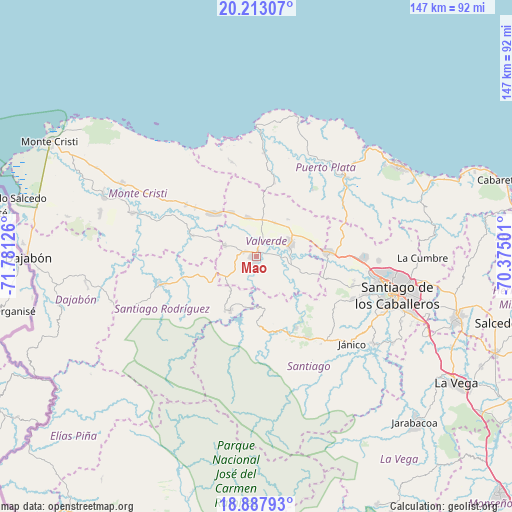
Mao GPS coordinates[2]
19° 33' 6.696" North, 71° 4' 41.268" West
| Map corner | latitude | longitude |
|---|---|---|
| Upper-left | 20.21307°, | -71.78126° |
| Center: | 19.55186°, | -71.07813° |
| Lower-right: | 18.88793°, | -70.37501° |
| Map W x H: | 147.3×147.3 km | = 91.5×91.5mi |
| max Lat: | 19.89131° ⇑16.6% North |
| Mao: | 19.55186° |
| min Lat: | ⇓83.4% South 17.80136° |
| min Long | Mao | max Long |
| -71.85022° | -71.07813° | -68.40431° |
| W 30.3%⇐ | ⇒69.7% E |
Elevation
Elevation of Mao is 85 m = 279 ft, and this is 81.3 m = 267 ft below average elevation for this country.
| Max E: |
1242 m = 4075 ft | 44.5% |
| Avg. | 166.3 m = 546 ft | |
| Mao | 85 m = 279 ft | |
Min E: |
5 m = 16 ft | 55.5% |
See also: Mao elevation on elevation.city.
Geographical zone
Mao is located in North Torrid zone (between Equator and Tropic of Cancer). Distance of this Northern Tropic circle is 432 km =268.4 mi to North.| Distance of | km | miles | from Mao |
|---|---|---|---|
| North Pole | 7833.1 | 4867.3 | to North |
| Arctic Circle | 5227.2 | 3248 | to North |
| Tropic Cancer | 432 | 268.4 | to North |
| Equator | 2174 | 1350.9 | to South |


Nearby cities:
15 places around Mao: (largest is in red/bold)
• Amina
8.6 km =5.3 mi,  92°
92°
• Cana Chapetón
19.8 km =12.3 mi,  288°
288°
• El Rubio
20.3 km =12.6 mi,  177°
177°
• Esperanza
10.4 km =6.5 mi,  69°
69°
• Guatapanal
17.6 km =10.9 mi,  106°
106°
• Hatillo Palma
17.3 km =10.7 mi,  315°
315°
• Jaibón
9.9 km =6.2 mi,  312°
312°
• Jicomé
17.3 km =10.7 mi,  51°
51°
• La Caya
17 km =10.6 mi,  344°
344°
• Laguna Salada
11 km =6.8 mi,  356°
356°
• Los Hidalgos
20.7 km =12.9 mi,  13°
13°
• Maizal
10.8 km =6.7 mi,  29°
29°
• Monción
17.5 km =10.9 mi,  206°
206°
• Villa Bisonó
21.2 km =13.2 mi, 86°
• Villa Elisa
25 km =15.5 mi, 306°
Sources, notices
• [Note1] Compared only with cities in Dominican Republic existing in our database
• [Src1] Map data: © OpenStreetMap contributors (CC-BY-SA)
• [Src2] Other city data from geonames.org with taken over terms of usage.
• [Src3] Geographical zone / Annual Mean Temperature by Robert A. Rohde @ Wikipedia
