Maizal geodata
Maizal (Valverde) is a populated place; located in Dominican Republic in America/Santo_Domingo (GMT-4) time zone. With population of 3,384 people, there are 141 cities with bigger population in this country. Compared to other cities in Dominican Republic, 88.6% of cities are located further ↓South; 67.3% of cities are located further →East and 55% of cities have lower elevation than Maizal. Note1
Administrative division(s):
- Level 1: Valverde
- Level 2: Esperanza
- Level 3: Maizal (D. M.).
- Level 4: Maizal (Zona Urbana)


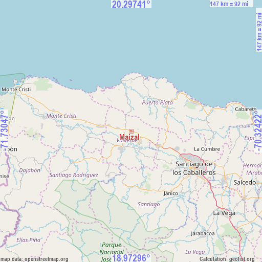
Maizal GPS coordinates[2]
19° 38' 11.58" North, 71° 1' 38.424" West
| Map corner | latitude | longitude |
|---|---|---|
| Upper-left | 20.29741°, | -71.73047° |
| Center: | 19.63655°, | -71.02734° |
| Lower-right: | 18.97296°, | -70.32422° |
| Map W x H: | 147.3×147.3 km | = 91.5×91.5mi |
| max Lat: | 19.89131° ⇑11.4% North |
| Maizal: | 19.63655° |
| min Lat: | ⇓88.6% South 17.80136° |
| min Long | Maizal | max Long |
| -71.85022° | -71.02734° | -68.40431° |
| W 32.7%⇐ | ⇒67.3% E |
Elevation
Elevation of Maizal is 82 m = 269 ft, and this is 84.3 m = 277 ft below average elevation for this country.
| Max E: |
1242 m = 4075 ft | 45% |
| Avg. | 166.3 m = 546 ft | |
| Maizal | 82 m = 269 ft | |
Min E: |
5 m = 16 ft | 55% |
See also: Dominican Republic elevation on elevation.city.
Geographical zone
Maizal is located in North Torrid zone (between Equator and Tropic of Cancer). Distance of this Northern Tropic circle is 422.5 km =262.5 mi to North.| Distance of | km | miles | from Maizal |
|---|---|---|---|
| North Pole | 7823.7 | 4861.4 | to North |
| Arctic Circle | 5217.8 | 3242.2 | to North |
| Tropic Cancer | 422.5 | 262.5 | to North |
| Equator | 2183.4 | 1356.7 | to South |


Nearby cities:
15 places around Maizal: (largest is in red/bold)
• Altamira
19.7 km =12.2 mi,  76°
76°
• Amina
10.4 km =6.5 mi,  161°
161°
• Cana Chapetón
24.3 km =15.1 mi,  262°
262°
• Esperanza
7.3 km =4.5 mi,  142°
142°
• Guananico
14.8 km =9.2 mi,  47°
47°
• Guatapanal
18.5 km =11.5 mi, 141°
• Hatillo Palma
17.7 km =11 mi,  279°
279°
• Jaibón
13 km =8.1 mi, 257°
• Jicomé
8.3 km =5.2 mi, 79°
• La Caya
12.1 km =7.5 mi,  305°
305°
• Laguna Salada
6.2 km =3.9 mi, 284°
• Los Hidalgos
10.8 km =6.7 mi,  356°
356°
• Mao
10.8 km =6.7 mi,  209°
209°
• Villa Bisonó
17.8 km =11.1 mi,  117°
117°
• Villa Isabela
20.2 km =12.6 mi,  350°
350°
Sources, notices
• [Note1] Compared only with cities in Dominican Republic existing in our database
• [Src1] Map data: © OpenStreetMap contributors (CC-BY-SA)
• [Src2] Other city data from geonames.org with taken over terms of usage.
• [Src3] Geographical zone / Annual Mean Temperature by Robert A. Rohde @ Wikipedia
