Los Hidalgos geodata
Los Hidalgos (Puerto Plata) is a populated place; located in Dominican Republic in America/Santo_Domingo (GMT-4) time zone. With population of 2,805 people, there are 150 cities with bigger population in this country. Compared to other cities in Dominican Republic, 95.3% of cities are located further ↓South; 67.8% of cities are located further →East and 73.5% of cities have lower elevation than Los Hidalgos. Note1
Administrative division(s):
- Level 1: Puerto Plata
- Level 2: Los Hidalgos
- Level 3: Los Hidalgos
- Level 4: Los Hidalgos (Zona Urbana)


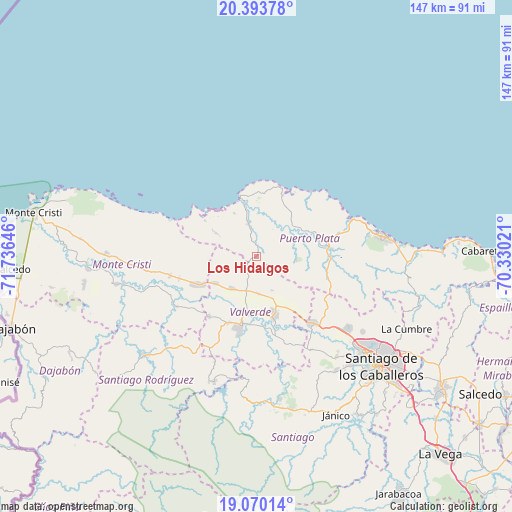
Los Hidalgos GPS coordinates[2]
19° 43' 59.988" North, 71° 1' 59.988" West
| Map corner | latitude | longitude |
|---|---|---|
| Upper-left | 20.39378°, | -71.73646° |
| Center: | 19.73333°, | -71.03333° |
| Lower-right: | 19.07014°, | -70.33021° |
| Map W x H: | 147.2×147.2 km | = 91.5×91.5mi |
| max Lat: | 19.89131° ⇑4.7% North |
| Los Hidalgos: | 19.73333° |
| min Lat: | ⇓95.3% South 17.80136° |
| min Long | Los Hidalgos | max Long |
| -71.85022° | -71.03333° | -68.40431° |
| W 32.2%⇐ | ⇒67.8% E |
Elevation
Elevation of Los Hidalgos is 195 m = 640 ft, and this is 28.7 m = 94 ft above average elevation for this country.
| Max E: |
1242 m = 4075 ft | 26.5% |
| Los Hidalgos | 195 m 640 ft | |
| Avg. | 166.3 m = 546 ft | |
Min E: |
5 m = 16 ft | 73.5% |
See also: Dominican Republic elevation on elevation.city.
Geographical zone
Los Hidalgos is located in North Torrid zone (between Equator and Tropic of Cancer). Distance of this Northern Tropic circle is 411.8 km =255.9 mi to North.| Distance of | km | miles | from Los Hidalgos |
|---|---|---|---|
| North Pole | 7812.9 | 4854.7 | to North |
| Arctic Circle | 5207 | 3235.5 | to North |
| Tropic Cancer | 411.8 | 255.9 | to North |
| Equator | 2194.1 | 1363.4 | to South |


Nearby cities:
15 places around Los Hidalgos: (largest is in red/bold)
• Altamira
20.7 km =12.9 mi,  107°
107°
• Amina
21 km =13 mi,  169°
169°
• Esperanza
17.3 km =10.7 mi,  162°
162°
• Estero Hondo
18 km =11.2 mi,  305°
305°
• Guananico
11.6 km =7.2 mi,  93°
93°
• Hatillo Palma
18.6 km =11.6 mi,  244°
244°
• Imbert
21.5 km =13.4 mi,  83°
83°
• Jaibón
18.1 km =11.2 mi,  221°
221°
• Jicomé
12.8 km =8 mi,  136°
136°
• La Caya
9.9 km =6.2 mi,  247°
247°
• Laguna Salada
10.7 km =6.6 mi,  210°
210°
• Luperón
19.1 km =11.9 mi,  23°
23°
• Maizal
10.8 km =6.7 mi,  176°
176°
• Mao
20.7 km =12.9 mi,  193°
193°
• Villa Isabela
9.6 km =6 mi,  342°
342°
Sources, notices
• [Note1] Compared only with cities in Dominican Republic existing in our database
• [Src1] Map data: © OpenStreetMap contributors (CC-BY-SA)
• [Src2] Other city data from geonames.org with taken over terms of usage.
• [Src3] Geographical zone / Annual Mean Temperature by Robert A. Rohde @ Wikipedia
