Oran geodata
Oran is a seat of a first-order administrative division; located in Algeria in Africa/Algiers (GMT+1) time zone. With population of 645,984 people, there are 2 cities with bigger population in this country. Compared to other cities in Algeria, 61.6% of cities are located further ↑North; 91.5% of cities are located further →East and 69.4% of cities have higher elevation than Oran. Note1


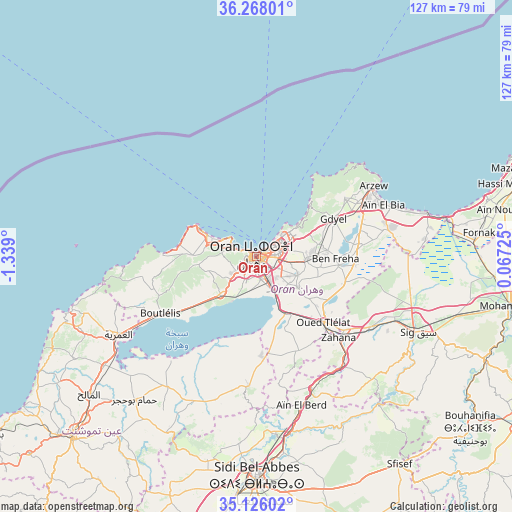
Oran GPS coordinates[2]
35° 41' 56.616" North, 0° 38' 9.168" West
| Map corner | latitude | longitude |
|---|---|---|
| Upper-left | 36.26801°, | -1.339° |
| Center: | 35.69906°, | -0.63588° |
| Lower-right: | 35.12602°, | 0.06725° |
| Map W x H: | 127×127 km | = 78.9×78.9mi |
| max Lat: | 36.92917° ⇑61.6% North |
| Oran: | 35.69906° |
| min Lat: | ⇓38.4% South 22.785° |
| min Long | Oran | max Long |
| -8.14743° | -0.63588° | 8.46667° |
| W 8.5%⇐ | ⇒91.5% E |
Elevation
Elevation of Oran is 118 m = 387 ft, and this is 320.5 m = 1052 ft below average elevation for this country.
| Max E: |
1392 m = 4567 ft | 69.4% |
| Avg. | 438.5 m = 1439 ft | |
| Oran | 118 m = 387 ft | |
Min E: |
5 m = 16 ft | 30.6% |
See also: Oran elevation on elevation.city.
Geographical zone
Oran is located in North temperate zone (between Tropic of Cancer and the Arctic Circle). Distance of this Northern Tropic circle is 1363.4 km =847.2 mi to South.| Distance of | km | miles | from Oran |
|---|---|---|---|
| North Pole | 6037.7 | 3751.7 | to North |
| Arctic Circle | 3431.8 | 2132.4 | to North |
| Tropic Cancer | 1363.4 | 847.2 | to South |
| Equator | 3969.4 | 2466.5 | to South |


Nearby cities:
15 places around Oran: (largest is in red/bold)
• Aïn Temouchent
63.9 km =39.7 mi,  225°
225°
• Aïn el Bya
32.3 km =20.1 mi,  68°
68°
• Bir el Djir
8.5 km =5.3 mi, 74°
• Bou Tlelis
27.7 km =17.2 mi,  239°
239°
• El Amria
39.5 km =24.5 mi, 240°
• El Malah
53.6 km =33.3 mi, 230°
• Es Senia
5.8 km =3.6 mi,  169°
169°
• Hammam Bou Hadjar
46.6 km =29 mi,  220°
220°
• Mers el Kebir
7.3 km =4.5 mi,  296°
296°
• Sfizef
62.6 km =38.9 mi,  145°
145°
• Sidi Bel Abbès
56.6 km =35.2 mi,  179°
179°
• Sidi ech Chahmi
11.2 km =7 mi,  113°
113°
• Sig
44.3 km =27.5 mi,  115°
115°
• ’Aïn el Berd
38.9 km =24.2 mi,  163°
163°
• ’Aïn el Turk
13 km =8.1 mi,  292°
292°
Sources, notices
• [Note1] Compared only with cities in Algeria existing in our database
• [Src1] Map data: © OpenStreetMap contributors (CC-BY-SA)
• [Src2] Other city data from geonames.org with taken over terms of usage.
• [Src3] Geographical zone / Annual Mean Temperature by Robert A. Rohde @ Wikipedia
