’Aïn el Turk geodata
’Aïn el Turk (Oran) is a populated place; located in Algeria in Africa/Algiers (GMT+1) time zone. With population of 45,323 people, there are 110 cities with bigger population in this country. Compared to other cities in Algeria, 58.5% of cities are located further ↑North; 92.2% of cities are located further →East and 91.1% of cities have higher elevation than ’Aïn el Turk. Note1


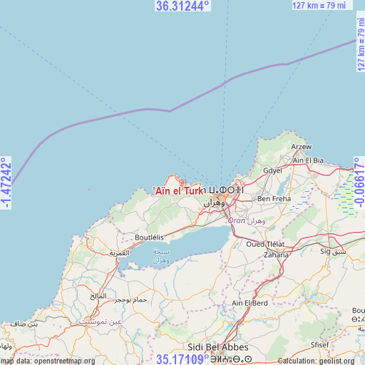
’Aïn el Turk GPS coordinates[2]
35° 44' 37.716" North, 0° 46' 9.48" West
| Map corner | latitude | longitude |
|---|---|---|
| Upper-left | 36.31244°, | -1.47242° |
| Center: | 35.74381°, | -0.7693° |
| Lower-right: | 35.17109°, | -0.06617° |
| Map W x H: | 126.9×126.9 km | = 78.9×78.9mi |
| max Lat: | 36.92917° ⇑58.5% North |
| ’Aïn el Turk: | 35.74381° |
| min Lat: | ⇓41.5% South 22.785° |
| min Long | ’Aïn el Turk | max Long |
| -8.14743° | -0.7693° | 8.46667° |
| W 7.8%⇐ | ⇒92.2% E |
Elevation
Elevation of ’Aïn el Turk is 31 m = 102 ft, and this is 407.5 m = 1337 ft below average elevation for this country.
| Max E: |
1392 m = 4567 ft | 91.1% |
| Avg. | 438.5 m = 1439 ft | |
| ’Aïn el Turk | 31 m = 102 ft | |
Min E: |
5 m = 16 ft | 8.9% |
See also: ’Aïn el Turk elevation on elevation.city.
Geographical zone
’Aïn el Turk is located in North temperate zone (between Tropic of Cancer and the Arctic Circle). Distance of this Northern Tropic circle is 1368.4 km =850.3 mi to South.| Distance of | km | miles | from ’Aïn el Turk |
|---|---|---|---|
| North Pole | 6032.7 | 3748.5 | to North |
| Arctic Circle | 3426.8 | 2129.3 | to North |
| Tropic Cancer | 1368.4 | 850.3 | to South |
| Equator | 3974.3 | 2469.5 | to South |


Nearby cities:
15 places around ’Aïn el Turk: (largest is in red/bold)
• Aïn Temouchent
59.9 km =37.2 mi,  214°
214°
• Aïn el Bya
42.7 km =26.5 mi,  80°
80°
• Bir el Djir
20.4 km =12.7 mi,  97°
97°
• Bou Tlelis
22.4 km =13.9 mi, 211°
• El Amria
33 km =20.5 mi,  222°
222°
• El Malah
48.9 km =30.4 mi, 216°
• Es Senia
16.9 km =10.5 mi,  129°
129°
• Hammam Bou Hadjar
44.4 km =27.6 mi,  203°
203°
• Mers el Kebir
5.8 km =3.6 mi,  107°
107°
• Oran
13 km =8.1 mi, 112°
• Sfizef
73.9 km =45.9 mi,  139°
139°
• Sidi Bel Abbès
62.8 km =39 mi,  168°
168°
• Sidi ech Chahmi
24.3 km =15.1 mi, 112°
• Sig
57.3 km =35.6 mi, 114°
• ’Aïn el Berd
48.2 km =30 mi,  151°
151°
Sources, notices
• [Note1] Compared only with cities in Algeria existing in our database
• [Src1] Map data: © OpenStreetMap contributors (CC-BY-SA)
• [Src2] Other city data from geonames.org with taken over terms of usage.
• [Src3] Geographical zone / Annual Mean Temperature by Robert A. Rohde @ Wikipedia
