El Malah geodata
El Malah (Aïn Témouchent) is a populated place; located in Algeria in Africa/Algiers (GMT+1) time zone. With population of 19,415 people, there are 234 cities with bigger population in this country. Compared to other cities in Algeria, 70.2% of cities are located further ↑North; 94.2% of cities are located further →East and 80.6% of cities have higher elevation than El Malah. Note1


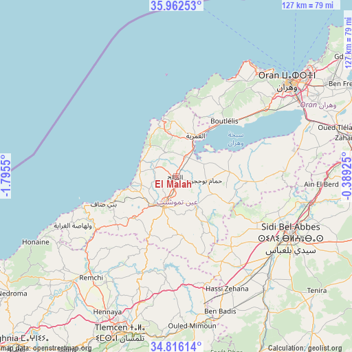
El Malah GPS coordinates[2]
35° 23' 28.932" North, 1° 5' 32.568" West
| Map corner | latitude | longitude |
|---|---|---|
| Upper-left | 35.96253°, | -1.7955° |
| Center: | 35.39137°, | -1.09238° |
| Lower-right: | 34.81614°, | -0.38925° |
| Map W x H: | 127.5×127.5 km | = 79.2×79.2mi |
| max Lat: | 36.92917° ⇑70.2% North |
| El Malah: | 35.39137° |
| min Lat: | ⇓29.8% South 22.785° |
| min Long | El Malah | max Long |
| -8.14743° | -1.09238° | 8.46667° |
| W 5.8%⇐ | ⇒94.2% E |
Elevation
Elevation of El Malah is 84 m = 276 ft, and this is 354.5 m = 1163 ft below average elevation for this country.
| Max E: |
1392 m = 4567 ft | 80.6% |
| Avg. | 438.5 m = 1439 ft | |
| El Malah | 84 m = 276 ft | |
Min E: |
5 m = 16 ft | 19.4% |
See also: Algeria elevation on elevation.city.
Geographical zone
El Malah is located in North temperate zone (between Tropic of Cancer and the Arctic Circle). Distance of this Northern Tropic circle is 1329.2 km =825.9 mi to South.| Distance of | km | miles | from El Malah |
|---|---|---|---|
| North Pole | 6071.9 | 3772.9 | to North |
| Arctic Circle | 3466 | 2153.7 | to North |
| Tropic Cancer | 1329.2 | 825.9 | to South |
| Equator | 3935.2 | 2445.2 | to South |


Nearby cities:
15 places around El Malah: (largest is in red/bold)
• Aïn Temouchent
11.3 km =7 mi,  202°
202°
• Beni Saf
28.1 km =17.5 mi,  249°
249°
• Bensekrane
37.2 km =23.1 mi, 198°
• Bou Tlelis
26.7 km =16.6 mi,  40°
40°
• El Amria
16.3 km =10.1 mi,  25°
25°
• Es Senia
51.1 km =31.8 mi,  56°
56°
• Hammam Bou Hadjar
11.4 km =7.1 mi,  97°
97°
• Mers el Kebir
51.1 km =31.8 mi, 42°
• Oran
53.6 km =33.3 mi,  50°
50°
• Remchi
48 km =29.8 mi,  220°
220°
• Sidi Abdelli
36 km =22.4 mi,  186°
186°
• Sidi Bel Abbès
47.5 km =29.5 mi,  118°
118°
• Sidi Senoussi سيدي سنوسي
43.9 km =27.3 mi,  180°
180°
• ’Aïn el Berd
52.6 km =32.7 mi,  93°
93°
• ’Aïn el Turk
48.9 km =30.4 mi, 36°
Sources, notices
• [Note1] Compared only with cities in Algeria existing in our database
• [Src1] Map data: © OpenStreetMap contributors (CC-BY-SA)
• [Src2] Other city data from geonames.org with taken over terms of usage.
• [Src3] Geographical zone / Annual Mean Temperature by Robert A. Rohde @ Wikipedia
