Aïn Temouchent geodata
Aïn Temouchent (Aïn Témouchent) is a seat of a first-order administrative division; located in Algeria in Africa/Algiers (GMT+1) time zone. With population of 57,354 people, there are 83 cities with bigger population in this country. Compared to other cities in Algeria, 73.3% of cities are located further ↑North; 95.3% of cities are located further →East and 56.2% of cities have higher elevation than Aïn Temouchent. Note1


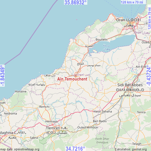
Aïn Temouchent GPS coordinates[2]
35° 17' 50.964" North, 1° 8' 25.332" West
| Map corner | latitude | longitude |
|---|---|---|
| Upper-left | 35.86932°, | -1.84349° |
| Center: | 35.29749°, | -1.14037° |
| Lower-right: | 34.7216°, | -0.43724° |
| Map W x H: | 127.6×127.6 km | = 79.3×79.3mi |
| max Lat: | 36.92917° ⇑73.3% North |
| Aïn Temouchent: | 35.29749° |
| min Lat: | ⇓26.7% South 22.785° |
| min Long | Aïn Temouchent | max Long |
| -8.14743° | -1.14037° | 8.46667° |
| W 4.7%⇐ | ⇒95.3% E |
Elevation
Elevation of Aïn Temouchent is 240 m = 787 ft, and this is 198.5 m = 651 ft below average elevation for this country.
| Max E: |
1392 m = 4567 ft | 56.2% |
| Avg. | 438.5 m = 1439 ft | |
| Aïn Temouchent | 240 m = 787 ft | |
Min E: |
5 m = 16 ft | 43.8% |
See also: Aïn Temouchent elevation on elevation.city.
Geographical zone
Aïn Temouchent is located in North temperate zone (between Tropic of Cancer and the Arctic Circle). Distance of this Northern Tropic circle is 1318.8 km =819.5 mi to South.| Distance of | km | miles | from Aïn Temouchent |
|---|---|---|---|
| North Pole | 6082.3 | 3779.4 | to North |
| Arctic Circle | 3476.5 | 2160.2 | to North |
| Tropic Cancer | 1318.8 | 819.5 | to South |
| Equator | 3924.7 | 2438.7 | to South |


Nearby cities:
15 places around Aïn Temouchent: (largest is in red/bold)
• Beni Saf
22 km =13.7 mi,  271°
271°
• Bensekrane
25.9 km =16.1 mi,  197°
197°
• Bou Tlelis
37.6 km =23.4 mi,  35°
35°
• Chetouane
44.1 km =27.4 mi, 198°
• El Amria
27.6 km =17.1 mi,  24°
24°
• El Malah
11.3 km =7 mi, 22°
• Hammam Bou Hadjar
18.1 km =11.2 mi,  59°
59°
• Hennaya
43.7 km =27.2 mi,  208°
208°
• Mansoûra
51.7 km =32.1 mi, 200°
• Ouled Mimoun
44.7 km =27.8 mi,  167°
167°
• Remchi
37.4 km =23.2 mi,  225°
225°
• Sidi Abdelli
25.4 km =15.8 mi,  179°
179°
• Sidi Bel Abbès
47.8 km =29.7 mi,  104°
104°
• Sidi Senoussi سيدي سنوسي
33.7 km =20.9 mi, 172°
• Tlemcen
49.2 km =30.6 mi, 198°
Sources, notices
• [Note1] Compared only with cities in Algeria existing in our database
• [Src1] Map data: © OpenStreetMap contributors (CC-BY-SA)
• [Src2] Other city data from geonames.org with taken over terms of usage.
• [Src3] Geographical zone / Annual Mean Temperature by Robert A. Rohde @ Wikipedia
