Sig geodata
Sig (Mascara) is a populated place; located in Algeria in Africa/Algiers (GMT+1) time zone. With population of 58,877 people, there are 80 cities with bigger population in this country. Compared to other cities in Algeria, 65.9% of cities are located further ↑North; 87.2% of cities are located further →East and 84.5% of cities have higher elevation than Sig. Note1


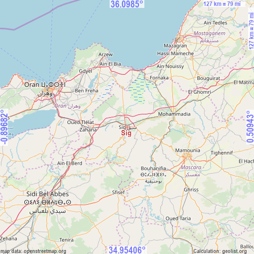
Sig GPS coordinates[2]
35° 31' 41.952" North, 0° 11' 37.284" West
| Map corner | latitude | longitude |
|---|---|---|
| Upper-left | 36.0985°, | -0.89682° |
| Center: | 35.52832°, | -0.19369° |
| Lower-right: | 34.95406°, | 0.50943° |
| Map W x H: | 127.2×127.2 km | = 79×79mi |
| max Lat: | 36.92917° ⇑65.9% North |
| Sig: | 35.52832° |
| min Lat: | ⇓34.1% South 22.785° |
| min Long | Sig | max Long |
| -8.14743° | -0.19369° | 8.46667° |
| W 12.8%⇐ | ⇒87.2% E |
Elevation
Elevation of Sig is 62 m = 203 ft, and this is 376.5 m = 1235 ft below average elevation for this country.
| Max E: |
1392 m = 4567 ft | 84.5% |
| Avg. | 438.5 m = 1439 ft | |
| Sig | 62 m = 203 ft | |
Min E: |
5 m = 16 ft | 15.5% |
See also: Sig elevation on elevation.city.
Geographical zone
Sig is located in North temperate zone (between Tropic of Cancer and the Arctic Circle). Distance of this Northern Tropic circle is 1344.5 km =835.4 mi to South.| Distance of | km | miles | from Sig |
|---|---|---|---|
| North Pole | 6056.7 | 3763.5 | to North |
| Arctic Circle | 3450.8 | 2144.2 | to North |
| Tropic Cancer | 1344.5 | 835.4 | to South |
| Equator | 3950.4 | 2454.7 | to South |


Nearby cities:
15 places around Sig: (largest is in red/bold)
• Aïn el Bya
32.2 km =20 mi,  342°
342°
• Bir el Djir
38.2 km =23.7 mi,  303°
303°
• Bou Hanifia el Hamamat
27.1 km =16.8 mi,  151°
151°
• Bou Tlelis
64 km =39.8 mi,  274°
274°
• Es Senia
41.1 km =25.5 mi,  288°
288°
• Mascara
33.6 km =20.9 mi,  115°
115°
• Mers el Kebir
51.5 km =32 mi, 295°
• Mostaganem
51.6 km =32.1 mi,  29°
29°
• Oran
44.3 km =27.5 mi, 295°
• Relizane
71.6 km =44.5 mi,  71°
71°
• Sfizef
33 km =20.5 mi,  188°
188°
• Sidi Bel Abbès
54.7 km =34 mi,  226°
226°
• Sidi ech Chahmi
33 km =20.5 mi, 296°
• ’Aïn el Berd
34.2 km =21.3 mi,  237°
237°
• ’Aïn el Turk
57.3 km =35.6 mi, 294°
Sources, notices
• [Note1] Compared only with cities in Algeria existing in our database
• [Src1] Map data: © OpenStreetMap contributors (CC-BY-SA)
• [Src2] Other city data from geonames.org with taken over terms of usage.
• [Src3] Geographical zone / Annual Mean Temperature by Robert A. Rohde @ Wikipedia
