Remchi geodata
Remchi (Tlemcen) is a populated place; located in Algeria in Africa/Algiers (GMT+1) time zone. With population of 51,224 people, there are 97 cities with bigger population in this country. Compared to other cities in Algeria, 77.1% of cities are located further ↑North; 98.8% of cities are located further →East and 57.8% of cities have higher elevation than Remchi. Note1


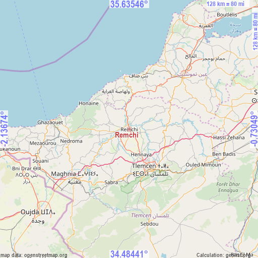
Remchi GPS coordinates[2]
35° 3' 43.056" North, 1° 26' 1.032" West
| Map corner | latitude | longitude |
|---|---|---|
| Upper-left | 35.63546°, | -2.13674° |
| Center: | 35.06196°, | -1.43362° |
| Lower-right: | 34.48441°, | -0.73049° |
| Map W x H: | 128×128 km | = 79.5×79.5mi |
| max Lat: | 36.92917° ⇑77.1% North |
| Remchi: | 35.06196° |
| min Lat: | ⇓22.9% South 22.785° |
| min Long | Remchi | max Long |
| -8.14743° | -1.43362° | 8.46667° |
| W 1.2%⇐ | ⇒98.8% E |
Elevation
Elevation of Remchi is 209 m = 686 ft, and this is 229.5 m = 753 ft below average elevation for this country.
| Max E: |
1392 m = 4567 ft | 57.8% |
| Avg. | 438.5 m = 1439 ft | |
| Remchi | 209 m = 686 ft | |
Min E: |
5 m = 16 ft | 42.2% |
See also: Remchi elevation on elevation.city.
Geographical zone
Remchi is located in North temperate zone (between Tropic of Cancer and the Arctic Circle). Distance of this Northern Tropic circle is 1292.6 km =803.2 mi to South.| Distance of | km | miles | from Remchi |
|---|---|---|---|
| North Pole | 6108.5 | 3795.6 | to North |
| Arctic Circle | 3502.6 | 2176.4 | to North |
| Tropic Cancer | 1292.6 | 803.2 | to South |
| Equator | 3898.5 | 2422.4 | to South |


Nearby cities:
15 places around Remchi: (largest is in red/bold)
• Aïn Temouchent
37.4 km =23.2 mi,  45°
45°
• Beni Mester
21.3 km =13.2 mi,  177°
177°
• Beni Saf
27 km =16.8 mi,  9°
9°
• Bensekrane
19.1 km =11.9 mi,  85°
85°
• Chetouane
20.1 km =12.5 mi,  141°
141°
• El Malah
48 km =29.8 mi,  40°
40°
• Hammam Bou Hadjar
55.1 km =34.2 mi, 50°
• Hennaya
13.7 km =8.5 mi,  154°
154°
• Mansoûra
23.9 km =14.9 mi,  158°
158°
• Nedroma
29.1 km =18.1 mi,  259°
259°
• Ouled Mimoun
40.4 km =25.1 mi,  115°
115°
• Sebdou
48.2 km =30 mi,  168°
168°
• Sidi Abdelli
27 km =16.8 mi, 88°
• Sidi Senoussi سيدي سنوسي
31.7 km =19.7 mi,  103°
103°
• Tlemcen
23.1 km =14.4 mi, 152°
Sources, notices
• [Note1] Compared only with cities in Algeria existing in our database
• [Src1] Map data: © OpenStreetMap contributors (CC-BY-SA)
• [Src2] Other city data from geonames.org with taken over terms of usage.
• [Src3] Geographical zone / Annual Mean Temperature by Robert A. Rohde @ Wikipedia
