Chetouane geodata
Chetouane (Tlemcen) is a populated place; located in Algeria in Africa/Algiers (GMT+1) time zone. With population of 39,913 people, there are 129 cities with bigger population in this country. Compared to other cities in Algeria, 78.7% of cities are located further ↑North; 96.1% of cities are located further →East and 65.9% of cities have lower elevation than Chetouane. Note1


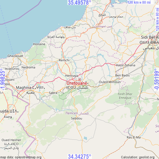
Chetouane GPS coordinates[2]
34° 55' 16.644" North, 1° 17' 42.432" West
| Map corner | latitude | longitude |
|---|---|---|
| Upper-left | 35.49578°, | -1.99825° |
| Center: | 34.92129°, | -1.29512° |
| Lower-right: | 34.34275°, | -0.59199° |
| Map W x H: | 128.2×128.2 km | = 79.7×79.7mi |
| max Lat: | 36.92917° ⇑78.7% North |
| Chetouane: | 34.92129° |
| min Lat: | ⇓21.3% South 22.785° |
| min Long | Chetouane | max Long |
| -8.14743° | -1.29512° | 8.46667° |
| W 3.9%⇐ | ⇒96.1% E |
Elevation
Elevation of Chetouane is 578 m = 1896 ft, and this is 139.5 m = 458 ft above average elevation for this country.
| Max E: |
1392 m = 4567 ft | 34.1% |
| Chetouane | 578 m 1896 ft | |
| Avg. | 438.5 m = 1439 ft | |
Min E: |
5 m = 16 ft | 65.9% |
See also: Algeria elevation on elevation.city.
Geographical zone
Chetouane is located in North temperate zone (between Tropic of Cancer and the Arctic Circle). Distance of this Northern Tropic circle is 1277 km =793.5 mi to South.| Distance of | km | miles | from Chetouane |
|---|---|---|---|
| North Pole | 6124.2 | 3805.4 | to North |
| Arctic Circle | 3518.3 | 2186.2 | to North |
| Tropic Cancer | 1277 | 793.5 | to South |
| Equator | 3882.9 | 2412.7 | to South |


Nearby cities:
15 places around Chetouane: (largest is in red/bold)
• Aïn Temouchent
44.1 km =27.4 mi,  18°
18°
• Beni Mester
13 km =8.1 mi,  244°
244°
• Beni Saf
43 km =26.7 mi,  349°
349°
• Bensekrane
18.2 km =11.3 mi, 20°
• El Malah
55.4 km =34.4 mi, 19°
• Hammam Bou Hadjar
58.9 km =36.6 mi,  30°
30°
• Hennaya
7.4 km =4.6 mi,  296°
296°
• Mansoûra
7.8 km =4.8 mi,  211°
211°
• Nedroma
42.5 km =26.4 mi,  283°
283°
• Ouled Mimoun
23.9 km =14.9 mi,  94°
94°
• Remchi
20.1 km =12.5 mi,  321°
321°
• Sebdou
31.8 km =19.8 mi,  185°
185°
• Sidi Abdelli
21.9 km =13.6 mi,  41°
41°
• Sidi Senoussi سيدي سنوسي
20.1 km =12.5 mi,  65°
65°
• Tlemcen
5.1 km =3.2 mi,  200°
200°
Sources, notices
• [Note1] Compared only with cities in Algeria existing in our database
• [Src1] Map data: © OpenStreetMap contributors (CC-BY-SA)
• [Src2] Other city data from geonames.org with taken over terms of usage.
• [Src3] Geographical zone / Annual Mean Temperature by Robert A. Rohde @ Wikipedia
