Tlemcen geodata
Tlemcen is a seat of a first-order administrative division; located in Algeria in Africa/Algiers (GMT+1) time zone. With population of 132,341 people, there are 27 cities with bigger population in this country. Compared to other cities in Algeria, 79.8% of cities are located further ↑North; 96.5% of cities are located further →East and 76% of cities have lower elevation than Tlemcen. Note1


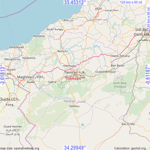
Tlemcen GPS coordinates[2]
34° 52' 41.988" North, 1° 18' 54" West
| Map corner | latitude | longitude |
|---|---|---|
| Upper-left | 35.45312°, | -2.01813° |
| Center: | 34.87833°, | -1.315° |
| Lower-right: | 34.29949°, | -0.61187° |
| Map W x H: | 128.3×128.3 km | = 79.7×79.7mi |
| max Lat: | 36.92917° ⇑79.8% North |
| Tlemcen: | 34.87833° |
| min Lat: | ⇓20.2% South 22.785° |
| min Long | Tlemcen | max Long |
| -8.14743° | -1.315° | 8.46667° |
| W 3.5%⇐ | ⇒96.5% E |
Elevation
Elevation of Tlemcen is 811 m = 2661 ft, and this is 372.5 m = 1222 ft above average elevation for this country.
| Max E: |
1392 m = 4567 ft | 24% |
| Tlemcen | 811 m 2661 ft | |
| Avg. | 438.5 m = 1439 ft | |
Min E: |
5 m = 16 ft | 76% |
See also: Tlemcen elevation on elevation.city.
Geographical zone
Tlemcen is located in North temperate zone (between Tropic of Cancer and the Arctic Circle). Distance of this Northern Tropic circle is 1272.2 km =790.5 mi to South.| Distance of | km | miles | from Tlemcen |
|---|---|---|---|
| North Pole | 6129 | 3808.4 | to North |
| Arctic Circle | 3523.1 | 2189.2 | to North |
| Tropic Cancer | 1272.2 | 790.5 | to South |
| Equator | 3878.1 | 2409.7 | to South |


Nearby cities:
15 places around Tlemcen: (largest is in red/bold)
• Aïn Temouchent
49.2 km =30.6 mi,  18°
18°
• Beni Mester
9.9 km =6.2 mi,  264°
264°
• Beni Saf
47.4 km =29.5 mi,  352°
352°
• Bensekrane
23.3 km =14.5 mi, 20°
• Chetouane
5.1 km =3.2 mi, 20°
• El Malah
60.5 km =37.6 mi, 19°
• Hammam Bou Hadjar
64 km =39.8 mi,  29°
29°
• Hennaya
9.5 km =5.9 mi,  329°
329°
• Mansoûra
2.9 km =1.8 mi,  230°
230°
• Nedroma
42.2 km =26.2 mi,  290°
290°
• Ouled Mimoun
25.8 km =16 mi,  83°
83°
• Remchi
23.1 km =14.4 mi, 332°
• Sebdou
26.9 km =16.7 mi,  183°
183°
• Sidi Abdelli
26.7 km =16.6 mi,  37°
37°
• Sidi Senoussi سيدي سنوسي
24 km =14.9 mi,  56°
56°
Sources, notices
• [Note1] Compared only with cities in Algeria existing in our database
• [Src1] Map data: © OpenStreetMap contributors (CC-BY-SA)
• [Src2] Other city data from geonames.org with taken over terms of usage.
• [Src3] Geographical zone / Annual Mean Temperature by Robert A. Rohde @ Wikipedia
