Akbou geodata
Akbou (Béjaïa) is a populated place; located in Algeria in Africa/Algiers (GMT+1) time zone. With population of 66,654 people, there are 67 cities with bigger population in this country. Compared to other cities in Algeria, 64% of cities are located further ↓South; 65.5% of cities are located further ←West and 57% of cities have higher elevation than Akbou. Note1


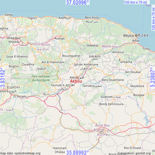
Akbou GPS coordinates[2]
36° 27' 27" North, 4° 32' 5.784" East
| Map corner | latitude | longitude |
|---|---|---|
| Upper-left | 37.02096°, | 3.83182° |
| Center: | 36.4575°, | 4.53494° |
| Lower-right: | 35.88992°, | 5.23807° |
| Map W x H: | 125.8×125.8 km | = 78.2×78.2mi |
| max Lat: | 36.92917° ⇑36% North |
| Akbou: | 36.4575° |
| min Lat: | ⇓64% South 22.785° |
| min Long | Akbou | max Long |
| -8.14743° | 4.53494° | 8.46667° |
| W 65.5%⇐ | ⇒34.5% E |
Elevation
Elevation of Akbou is 215 m = 705 ft, and this is 223.5 m = 733 ft below average elevation for this country.
| Max E: |
1392 m = 4567 ft | 57% |
| Avg. | 438.5 m = 1439 ft | |
| Akbou | 215 m = 705 ft | |
Min E: |
5 m = 16 ft | 43% |
See also: Akbou elevation on elevation.city.
Geographical zone
Akbou is located in North temperate zone (between Tropic of Cancer and the Arctic Circle). Distance of this Northern Tropic circle is 1447.8 km =899.6 mi to South.| Distance of | km | miles | from Akbou |
|---|---|---|---|
| North Pole | 5953.4 | 3699.3 | to North |
| Arctic Circle | 3347.5 | 2080 | to North |
| Tropic Cancer | 1447.8 | 899.6 | to South |
| Equator | 4053.7 | 2518.9 | to South |


Nearby cities:
15 places around Akbou: (largest is in red/bold)
• Ait Yahia
23.1 km =14.4 mi,  309°
309°
• Amizour
38.5 km =23.9 mi,  58°
58°
• Azazga
35.1 km =21.8 mi,  335°
335°
• Bordj Zemoura
35.3 km =21.9 mi,  125°
125°
• Chemini
17.4 km =10.8 mi,  24°
24°
• Chorfa
21.3 km =13.2 mi,  241°
241°
• El Kseur
37.8 km =23.5 mi,  49°
49°
• Feraoun
30.8 km =19.1 mi,  68°
68°
• Freha
38.2 km =23.7 mi,  329°
329°
• Ighram
2.7 km =1.7 mi,  282°
282°
• L’Arbaa Naït Irathen
35.7 km =22.2 mi,  302°
302°
• Mekla
34.8 km =21.6 mi,  315°
315°
• Seddouk
16.8 km =10.4 mi, 53°
• el hed
30.2 km =18.8 mi,  44°
44°
• ’Aïn el Hammam
23.7 km =14.7 mi, 300°
Sources, notices
• [Note1] Compared only with cities in Algeria existing in our database
• [Src1] Map data: © OpenStreetMap contributors (CC-BY-SA)
• [Src2] Other city data from geonames.org with taken over terms of usage.
• [Src3] Geographical zone / Annual Mean Temperature by Robert A. Rohde @ Wikipedia
