Eloy Alfaro geodata
Eloy Alfaro (Guayas) is a populated place; located in Ecuador in America/Guayaquil (GMT-5) time zone. With population of 167,784 people, there are 7 cities with bigger population in this country. Compared to other cities in Ecuador, 68.6% of cities are located further ↑North; 70.2% of cities are located further →East and 95.9% of cities have higher elevation than Eloy Alfaro. Note1


Eloy Alfaro GPS coordinates[2]
2° 10' 32.844" South, 79° 51' 18.684" West
| Map corner | latitude | longitude |
|---|---|---|
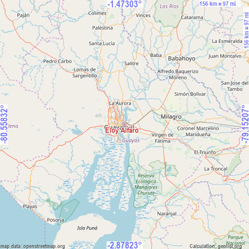
| Upper-left | -1.47303°, | -80.55832° |
| Center: | -2.17579°, | -79.85519° |
| Lower-right: | -2.87823°, | -79.15207° |
| Map W x H: | 156.2×156.2 km | = 97.1×97.1mi |
| max Lat: | 1.35251° ⇑68.6% North |
| Eloy Alfaro: | -2.17579° |
| min Lat: | ⇓31.4% South -4.38181° |
| min Long | Eloy Alfaro | max Long |
| -90.96654° | -79.85519° | -76.89528° |
| W 29.8%⇐ | ⇒70.2% E |
Elevation
Elevation of Eloy Alfaro is 7 m = 23 ft, and this is 938.1 m = 3078 ft below average elevation for this country.
| Max E: |
3131 m = 10272 ft | 95.9% |
| Avg. | 945.1 m = 3101 ft | |
| Eloy Alfaro | 7 m = 23 ft | |
Min E: |
1 m = 3 ft | 4.1% |
See also: Eloy Alfaro elevation on elevation.city.
Geographical zone
Eloy Alfaro is located in South Torrid zone (between Equator and Tropic of Capricorn). Distance of Equator is 241.9 km =150.3 mi to North.| Distance of | km | miles | from Eloy Alfaro |
|---|---|---|---|
| Equator | 241.9 | 150.3 | to North |
| Tropic Capricorn | 2364 | 1468.9 | to South |
| Antarctic Circle | 7159.2 | 4448.5 | to South |
| South Pole | 9765.1 | 6067.7 | to South |


Nearby cities:
15 places around Eloy Alfaro: (largest is in red/bold)
• Alfredo Baquerizo Moreno
47.4 km =29.5 mi,  52°
52°
• Babahoyo
54.7 km =34 mi,  40°
40°
• Coronel Marcelino Maridueña
47.1 km =29.3 mi,  94°
94°
• El Triunfo
29.7 km =18.5 mi,  335°
335°
• Guayaquil
4.1 km =2.5 mi,  236°
236°
• La Troncal
63.5 km =39.5 mi,  115°
115°
• Lomas de Sargentillo
41.2 km =25.6 mi,  322°
322°
• Milagro
29.4 km =18.3 mi,  80°
80°
• Naranjal
61.3 km =38.1 mi,  154°
154°
• Naranjito
43.3 km =26.9 mi, 88°
• Palestina
30.8 km =19.1 mi,  30°
30°
• Pedro Carbo
58 km =36 mi,  313°
313°
• Samborondón
27.8 km =17.3 mi, 31°
• Santa Lucía
16.1 km =10 mi,  267°
267°
• Yaguachi Nuevo
19.9 km =12.4 mi,  63°
63°
Sources, notices
• [Note1] Compared only with cities in Ecuador existing in our database
• [Src1] Map data: © OpenStreetMap contributors (CC-BY-SA)
• [Src2] Other city data from geonames.org with taken over terms of usage.
• [Src3] Geographical zone / Annual Mean Temperature by Robert A. Rohde @ Wikipedia
