Babahoyo geodata
Babahoyo (Los Ríos) is a seat of a first-order administrative division; located in Ecuador in America/Guayaquil (GMT-5) time zone. With population of 76,279 people, there are 17 cities with bigger population in this country. Compared to other cities in Ecuador, 59.5% of cities are located further ↑North; 54.5% of cities are located further →East and 87.6% of cities have higher elevation than Babahoyo. Note1


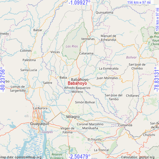
Babahoyo GPS coordinates[2]
1° 48' 7.812" South, 79° 32' 3.948" West
| Map corner | latitude | longitude |
|---|---|---|
| Upper-left | -1.09927°, | -80.23756° |
| Center: | -1.80217°, | -79.53443° |
| Lower-right: | -2.50479°, | -78.83131° |
| Map W x H: | 156.3×156.3 km | = 97.1×97.1mi |
| max Lat: | 1.35251° ⇑59.5% North |
| Babahoyo: | -1.80217° |
| min Lat: | ⇓40.5% South -4.38181° |
| min Long | Babahoyo | max Long |
| -90.96654° | -79.53443° | -76.89528° |
| W 45.5%⇐ | ⇒54.5% E |
Elevation
Elevation of Babahoyo is 10 m = 33 ft, and this is 935.1 m = 3068 ft below average elevation for this country.
| Max E: |
3131 m = 10272 ft | 87.6% |
| Avg. | 945.1 m = 3101 ft | |
| Babahoyo | 10 m = 33 ft | |
Min E: |
1 m = 3 ft | 12.4% |
See also: Babahoyo elevation on elevation.city.
Geographical zone
Babahoyo is located in South Torrid zone (between Equator and Tropic of Capricorn). Distance of Equator is 200.4 km =124.5 mi to North.| Distance of | km | miles | from Babahoyo |
|---|---|---|---|
| Equator | 200.4 | 124.5 | to North |
| Tropic Capricorn | 2405.5 | 1494.7 | to South |
| Antarctic Circle | 7200.8 | 4474.4 | to South |
| South Pole | 9806.7 | 6093.6 | to South |


Nearby cities:
15 places around Babahoyo: (largest is in red/bold)
• Alfredo Baquerizo Moreno
12.9 km =8 mi,  171°
171°
• Catarama
26.6 km =16.5 mi,  18°
18°
• Coronel Marcelino Maridueña
46.7 km =29 mi, 165°
• El Triunfo
50.2 km =31.2 mi,  253°
253°
• Eloy Alfaro
54.7 km =34 mi,  220°
220°
• Milagro
37.5 km =23.3 mi,  190°
190°
• Montalvo
27.5 km =17.1 mi,  87°
87°
• Naranjito
41.3 km =25.7 mi, 169°
• Palenque
47.4 km =29.5 mi,  328°
328°
• Palestina
25 km =15.5 mi,  233°
233°
• Samborondón
27.6 km =17.1 mi, 229°
• San Miguel
55.6 km =34.5 mi,  79°
79°
• Ventanas
41 km =25.5 mi,  11°
11°
• Vinces
36.5 km =22.7 mi,  318°
318°
• Yaguachi Nuevo
37.3 km =23.2 mi,  208°
208°
Sources, notices
• [Note1] Compared only with cities in Ecuador existing in our database
• [Src1] Map data: © OpenStreetMap contributors (CC-BY-SA)
• [Src2] Other city data from geonames.org with taken over terms of usage.
• [Src3] Geographical zone / Annual Mean Temperature by Robert A. Rohde @ Wikipedia
