Naranjal geodata
Naranjal (Guayas) is a populated place; located in Ecuador in America/Guayaquil (GMT-5) time zone. With population of 32,045 people, there are 39 cities with bigger population in this country. Compared to other cities in Ecuador, 80.2% of cities are located further ↑North; 57.9% of cities are located further →East and 71.9% of cities have higher elevation than Naranjal. Note1


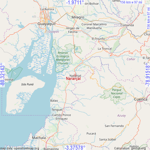
Naranjal GPS coordinates[2]
2° 40' 25.104" South, 79° 37' 5.88" West
| Map corner | latitude | longitude |
|---|---|---|
| Upper-left | -1.9711°, | -80.32143° |
| Center: | -2.67364°, | -79.6183° |
| Lower-right: | -3.37578°, | -78.91518° |
| Map W x H: | 156.2×156.2 km | = 97.1×97.1mi |
| max Lat: | 1.35251° ⇑80.2% North |
| Naranjal: | -2.67364° |
| min Lat: | ⇓19.8% South -4.38181° |
| min Long | Naranjal | max Long |
| -90.96654° | -79.6183° | -76.89528° |
| W 42.1%⇐ | ⇒57.9% E |
Elevation
Elevation of Naranjal is 25 m = 82 ft, and this is 920.1 m = 3019 ft below average elevation for this country.
| Max E: |
3131 m = 10272 ft | 71.9% |
| Avg. | 945.1 m = 3101 ft | |
| Naranjal | 25 m = 82 ft | |
Min E: |
1 m = 3 ft | 28.1% |
See also: Ecuador elevation on elevation.city.
Geographical zone
Naranjal is located in South Torrid zone (between Equator and Tropic of Capricorn). Distance of Equator is 297.3 km =184.7 mi to North.| Distance of | km | miles | from Naranjal |
|---|---|---|---|
| Equator | 297.3 | 184.7 | to North |
| Tropic Capricorn | 2308.6 | 1434.5 | to South |
| Antarctic Circle | 7103.9 | 4414.2 | to South |
| South Pole | 9709.8 | 6033.4 | to South |


Nearby cities:
15 places around Naranjal: (largest is in red/bold)
• Baláo
34.2 km =21.3 mi,  219°
219°
• Cañar
76.4 km =47.5 mi,  80°
80°
• Coronel Marcelino Maridueña
55.6 km =34.5 mi,  21°
21°
• Cuenca
72.7 km =45.2 mi,  110°
110°
• Eloy Alfaro
61.3 km =38.1 mi,  334°
334°
• Guayaquil
60.9 km =37.8 mi, 330°
• La Troncal
41.6 km =25.8 mi,  48°
48°
• Machala
75.3 km =46.8 mi,  210°
210°
• Milagro
60.1 km =37.3 mi,  2°
2°
• Naranjito
58.9 km =36.6 mi, 16°
• Pasaje
75.5 km =46.9 mi,  196°
196°
• Puerto Bolívar
78.2 km =48.6 mi, 212°
• Samborondón
79.9 km =49.6 mi,  351°
351°
• Santa Lucía
69.1 km =42.9 mi,  322°
322°
• Yaguachi Nuevo
64.7 km =40.2 mi, 352°
Sources, notices
• [Note1] Compared only with cities in Ecuador existing in our database
• [Src1] Map data: © OpenStreetMap contributors (CC-BY-SA)
• [Src2] Other city data from geonames.org with taken over terms of usage.
• [Src3] Geographical zone / Annual Mean Temperature by Robert A. Rohde @ Wikipedia
