Pedro Carbo geodata
Pedro Carbo (Guayas) is a populated place; located in Ecuador in America/Guayaquil (GMT-5) time zone. With population of 23,372 people, there are 48 cities with bigger population in this country. Compared to other cities in Ecuador, 60.3% of cities are located further ↑North; 85.1% of cities are located further →East and 59.5% of cities have higher elevation than Pedro Carbo. Note1


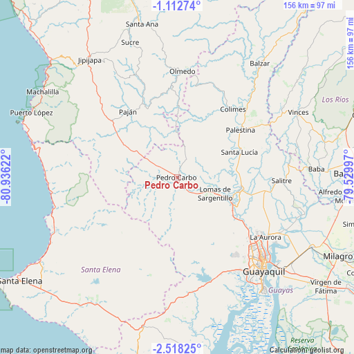
Pedro Carbo GPS coordinates[2]
1° 48' 56.268" South, 80° 13' 59.124" West
| Map corner | latitude | longitude |
|---|---|---|
| Upper-left | -1.11274°, | -80.93622° |
| Center: | -1.81563°, | -80.23309° |
| Lower-right: | -2.51825°, | -79.52997° |
| Map W x H: | 156.3×156.3 km | = 97.1×97.1mi |
| max Lat: | 1.35251° ⇑60.3% North |
| Pedro Carbo: | -1.81563° |
| min Lat: | ⇓39.7% South -4.38181° |
| min Long | Pedro Carbo | max Long |
| -90.96654° | -80.23309° | -76.89528° |
| W 14.9%⇐ | ⇒85.1% E |
Elevation
Elevation of Pedro Carbo is 56 m = 184 ft, and this is 889.1 m = 2917 ft below average elevation for this country.
| Max E: |
3131 m = 10272 ft | 59.5% |
| Avg. | 945.1 m = 3101 ft | |
| Pedro Carbo | 56 m = 184 ft | |
Min E: |
1 m = 3 ft | 40.5% |
See also: Ecuador elevation on elevation.city.
Geographical zone
Pedro Carbo is located in South Torrid zone (between Equator and Tropic of Capricorn). Distance of Equator is 201.9 km =125.5 mi to North.| Distance of | km | miles | from Pedro Carbo |
|---|---|---|---|
| Equator | 201.9 | 125.5 | to North |
| Tropic Capricorn | 2404 | 1493.8 | to South |
| Antarctic Circle | 7199.3 | 4473.4 | to South |
| South Pole | 9805.2 | 6092.7 | to South |


Nearby cities:
15 places around Pedro Carbo: (largest is in red/bold)
• Balzar
62 km =38.5 mi,  36°
36°
• Colimes
38.8 km =24.1 mi, 39°
• El Triunfo
32.4 km =20.1 mi,  113°
113°
• Eloy Alfaro
58 km =36 mi,  133°
133°
• Guayaquil
57.2 km =35.5 mi,  137°
137°
• Jipijapa
64.6 km =40.1 mi,  323°
323°
• Lomas de Sargentillo
18.3 km =11.4 mi, 114°
• Paján
36.5 km =22.7 mi, 323°
• Palenque
67.6 km =42 mi,  51°
51°
• Palestina
59.3 km =36.8 mi,  103°
103°
• Samborondón
58.9 km =36.6 mi, 106°
• Santa Lucía
48.4 km =30.1 mi,  147°
147°
• Sucre
63.1 km =39.2 mi,  340°
340°
• Vinces
60.8 km =37.8 mi,  61°
61°
• Yaguachi Nuevo
67.5 km =41.9 mi,  117°
117°
Sources, notices
• [Note1] Compared only with cities in Ecuador existing in our database
• [Src1] Map data: © OpenStreetMap contributors (CC-BY-SA)
• [Src2] Other city data from geonames.org with taken over terms of usage.
• [Src3] Geographical zone / Annual Mean Temperature by Robert A. Rohde @ Wikipedia
