Vändra geodata
Vändra (Pärnumaa) is a seat of a second-order administrative division; located in Estonia in Europe/Tallinn (GMT+3) time zone. With population of 2,544 people, there are 41 cities with bigger population in this country. Compared to other cities in Estonia, 58.9% of cities are located further ↑North; 60% of cities are located further →East and 66.8% of cities have higher elevation than Vändra. Note1


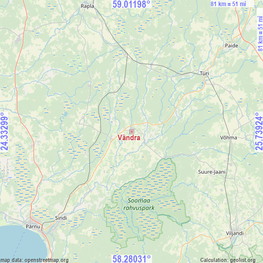
Vändra GPS coordinates[2]
58° 38' 53.016" North, 25° 2' 9.996" East
| Map corner | latitude | longitude |
|---|---|---|
| Upper-left | 59.01198°, | 24.33299° |
| Center: | 58.64806°, | 25.03611° |
| Lower-right: | 58.28031°, | 25.73924° |
| Map W x H: | 81.4×81.4 km | = 50.6×50.6mi |
| max Lat: | 59.57639° ⇑58.9% North |
| Vändra: | 58.64806° |
| min Lat: | ⇓41.1% South 57.72778° |
| min Long | Vändra | max Long |
| 22.24646° | 25.03611° | 28.19028° |
| W 40%⇐ | ⇒60% E |
Elevation
Elevation of Vändra is 42 m = 138 ft, and this is 11.2 m = 37 ft below average elevation for this country.
| Max E: |
141 m = 463 ft | 66.8% |
| Avg. | 53.2 m = 175 ft | |
| Vändra | 42 m = 138 ft | |
Min E: |
6 m = 20 ft | 33.2% |
See also: Estonia elevation on elevation.city.
Geographical zone
Vändra is located in North temperate zone (between Tropic of Cancer and the Arctic Circle). Distance of this North polar circle is 880.1 km =546.9 mi to North.| Distance of | km | miles | from Vändra |
|---|---|---|---|
| North Pole | 3486 | 2166.1 | to North |
| Arctic Circle | 880.1 | 546.9 | to North |
| Tropic Cancer | 3915.1 | 2432.7 | to South |
| Equator | 6521.1 | 4052 | to South |


Nearby cities:
15 places around Vändra: (largest is in red/bold)
• Järvakandi
18.9 km =11.7 mi,  320°
320°
• Kaerepere
37 km =23 mi,  342°
342°
• Kehtna
32.7 km =20.3 mi, 343°
• Olustvere
32.3 km =20.1 mi,  108°
108°
• Paikuse
37.9 km =23.5 mi,  217°
217°
• Pärnu-Jaagupi
30.9 km =19.2 mi,  262°
262°
• Sindi
34.9 km =21.7 mi, 217°
• Suure-Jaani
28.1 km =17.5 mi,  116°
116°
• Särevere
27.6 km =17.1 mi,  55°
55°
• Tootsi
16.1 km =10 mi,  241°
241°
• Tori
22.5 km =14 mi,  213°
213°
• Türi
29 km =18 mi,  52°
52°
• Türi-Alliku
30.5 km =19 mi, 52°
• Vyatsa
35.5 km =22.1 mi,  41°
41°
• Võhma
29.7 km =18.5 mi,  94°
94°
Sources, notices
• [Note1] Compared only with cities in Estonia existing in our database
• [Src1] Map data: © OpenStreetMap contributors (CC-BY-SA)
• [Src2] Other city data from geonames.org with taken over terms of usage.
• [Src3] Geographical zone / Annual Mean Temperature by Robert A. Rohde @ Wikipedia
