Voka geodata
Voka (Ida-Virumaa) is a populated place; located in Estonia in Europe/Tallinn (GMT+3) time zone. With population of 1,046 people, there are 86 cities with bigger population in this country. Compared to other cities in Estonia, 87.9% of cities are located further ↓South; 97.4% of cities are located further ←West and 74.2% of cities have higher elevation than Voka. Note1


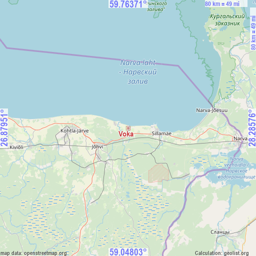
Voka GPS coordinates[2]
59° 24' 27.936" North, 27° 34' 57.468" East
| Map corner | latitude | longitude |
|---|---|---|
| Upper-left | 59.76371°, | 26.87951° |
| Center: | 59.40776°, | 27.58263° |
| Lower-right: | 59.04803°, | 28.28576° |
| Map W x H: | 79.6×79.6 km | = 49.5×49.5mi |
| max Lat: | 59.57639° ⇑12.1% North |
| Voka: | 59.40776° |
| min Lat: | ⇓87.9% South 57.72778° |
| min Long | Voka | max Long |
| 22.24646° | 27.58263° | 28.19028° |
| W 97.4%⇐ | ⇒2.6% E |
Elevation
Elevation of Voka is 35 m = 115 ft, and this is 18.2 m = 60 ft below average elevation for this country.
| Max E: |
141 m = 463 ft | 74.2% |
| Avg. | 53.2 m = 175 ft | |
| Voka | 35 m = 115 ft | |
Min E: |
6 m = 20 ft | 25.8% |
See also: Estonia elevation on elevation.city.
Geographical zone
Voka is located in North temperate zone (between Tropic of Cancer and the Arctic Circle). Distance of this North polar circle is 795.7 km =494.4 mi to North.| Distance of | km | miles | from Voka |
|---|---|---|---|
| North Pole | 3401.5 | 2113.6 | to North |
| Arctic Circle | 795.7 | 494.4 | to North |
| Tropic Cancer | 3999.6 | 2485.2 | to South |
| Equator | 6605.5 | 4104.5 | to South |


Nearby cities:
15 places around Voka: (largest is in red/bold)
• Aseri
40.7 km =25.3 mi,  276°
276°
• Iisaku
37.5 km =23.3 mi,  204°
204°
• Järve
15.4 km =9.6 mi,  269°
269°
• Jõhvi
10.6 km =6.6 mi,  239°
239°
• Kiviõli
35.2 km =21.9 mi,  260°
260°
• Kohtla-Järve
17.5 km =10.9 mi, 266°
• Kohtla-Nõmme
23.9 km =14.9 mi,  254°
254°
• Mäetaguse
26.5 km =16.5 mi,  221°
221°
• Narva
34.6 km =21.5 mi,  95°
95°
• Narva-Jõesuu
26.5 km =16.5 mi,  77°
77°
• Olgina
30.7 km =19.1 mi,  92°
92°
• Püssi
30.6 km =19 mi, 260°
• Sillamäe
10.3 km =6.4 mi, 96°
• Sonda
42.9 km =26.7 mi, 260°
• Toila
4.5 km =2.8 mi,  289°
289°
Sources, notices
• [Note1] Compared only with cities in Estonia existing in our database
• [Src1] Map data: © OpenStreetMap contributors (CC-BY-SA)
• [Src2] Other city data from geonames.org with taken over terms of usage.
• [Src3] Geographical zone / Annual Mean Temperature by Robert A. Rohde @ Wikipedia
