Kohtla-Nõmme geodata
Kohtla-Nõmme (Ida-Virumaa) is a populated place; located in Estonia in Europe/Tallinn (GMT+3) time zone. With population of 1,075 people, there are 78 cities with bigger population in this country. Compared to other cities in Estonia, 77.9% of cities are located further ↓South; 92.1% of cities are located further ←West and 53.2% of cities have lower elevation than Kohtla-Nõmme. Note1


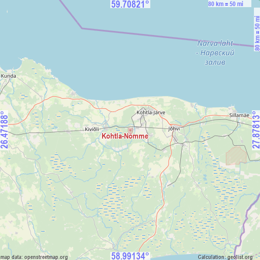
Kohtla-Nõmme GPS coordinates[2]
59° 21' 6.012" North, 27° 10' 30" East
| Map corner | latitude | longitude |
|---|---|---|
| Upper-left | 59.70821°, | 26.47188° |
| Center: | 59.35167°, | 27.175° |
| Lower-right: | 58.99134°, | 27.87813° |
| Map W x H: | 79.7×79.7 km | = 49.5×49.5mi |
| max Lat: | 59.57639° ⇑22.1% North |
| Kohtla-Nõmme: | 59.35167° |
| min Lat: | ⇓77.9% South 57.72778° |
| min Long | Kohtla-Nõmme | max Long |
| 22.24646° | 27.175° | 28.19028° |
| W 92.1%⇐ | ⇒7.9% E |
Elevation
Elevation of Kohtla-Nõmme is 55 m = 180 ft, and this is 1.8 m = 6 ft above average elevation for this country.
| Max E: |
141 m = 463 ft | 46.8% |
| Kohtla-Nõmme | 55 m 180 ft | |
| Avg. | 53.2 m = 175 ft | |
Min E: |
6 m = 20 ft | 53.2% |
See also: Estonia elevation on elevation.city.
Geographical zone
Kohtla-Nõmme is located in North temperate zone (between Tropic of Cancer and the Arctic Circle). Distance of this North polar circle is 801.9 km =498.3 mi to North.| Distance of | km | miles | from Kohtla-Nõmme |
|---|---|---|---|
| North Pole | 3407.8 | 2117.5 | to North |
| Arctic Circle | 801.9 | 498.3 | to North |
| Tropic Cancer | 3993.4 | 2481.4 | to South |
| Equator | 6599.3 | 4100.6 | to South |


Nearby cities:
15 places around Kohtla-Nõmme: (largest is in red/bold)
• Aseri
20.6 km =12.8 mi,  302°
302°
• Iisaku
28.8 km =17.9 mi,  164°
164°
• Järve
9.8 km =6.1 mi,  52°
52°
• Jõhvi
14 km =8.7 mi,  86°
86°
• Kiviõli
11.6 km =7.2 mi,  270°
270°
• Kohtla-Järve
7.6 km =4.7 mi, 46°
• Kunda
39.1 km =24.3 mi,  291°
291°
• Kunda
40.2 km =25 mi, 293°
• Mäetaguse
14.6 km =9.1 mi, 157°
• Püssi
7.2 km =4.5 mi,  277°
277°
• Roela
38.4 km =23.9 mi,  238°
238°
• Sillamäe
33.7 km =20.9 mi,  81°
81°
• Sonda
19.2 km =11.9 mi, 267°
• Toila
20.4 km =12.7 mi,  67°
67°
• Voka
23.9 km =14.9 mi, 74°
Sources, notices
• [Note1] Compared only with cities in Estonia existing in our database
• [Src1] Map data: © OpenStreetMap contributors (CC-BY-SA)
• [Src2] Other city data from geonames.org with taken over terms of usage.
• [Src3] Geographical zone / Annual Mean Temperature by Robert A. Rohde @ Wikipedia
