Mäetaguse geodata
Mäetaguse (Ida-Virumaa) is a populated place; located in Estonia in Europe/Tallinn (GMT+3) time zone. With population of 542 people, there are 160 cities with bigger population in this country. Compared to other cities in Estonia, 66.3% of cities are located further ↓South; 92.6% of cities are located further ←West and 60.5% of cities have lower elevation than Mäetaguse. Note1


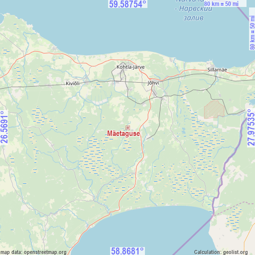
Mäetaguse GPS coordinates[2]
59° 13' 46.992" North, 27° 16' 19.992" East
| Map corner | latitude | longitude |
|---|---|---|
| Upper-left | 59.58754°, | 26.5691° |
| Center: | 59.22972°, | 27.27222° |
| Lower-right: | 58.8681°, | 27.97535° |
| Map W x H: | 80×80 km | = 49.7×49.7mi |
| max Lat: | 59.57639° ⇑33.7% North |
| Mäetaguse: | 59.22972° |
| min Lat: | ⇓66.3% South 57.72778° |
| min Long | Mäetaguse | max Long |
| 22.24646° | 27.27222° | 28.19028° |
| W 92.6%⇐ | ⇒7.4% E |
Elevation
Elevation of Mäetaguse is 61 m = 200 ft, and this is 7.8 m = 26 ft above average elevation for this country.
| Max E: |
141 m = 463 ft | 39.5% |
| Mäetaguse | 61 m 200 ft | |
| Avg. | 53.2 m = 175 ft | |
Min E: |
6 m = 20 ft | 60.5% |
See also: Estonia elevation on elevation.city.
Geographical zone
Mäetaguse is located in North temperate zone (between Tropic of Cancer and the Arctic Circle). Distance of this North polar circle is 815.4 km =506.7 mi to North.| Distance of | km | miles | from Mäetaguse |
|---|---|---|---|
| North Pole | 3421.3 | 2125.9 | to North |
| Arctic Circle | 815.4 | 506.7 | to North |
| Tropic Cancer | 3979.8 | 2472.9 | to South |
| Equator | 6585.7 | 4092.2 | to South |


Nearby cities:
15 places around Mäetaguse: (largest is in red/bold)
• Aseri
33.6 km =20.9 mi,  316°
316°
• Avinurme
36.1 km =22.4 mi,  220°
220°
• Iisaku
14.4 km =8.9 mi,  171°
171°
• Järve
19.7 km =12.2 mi,  6°
6°
• Jõhvi
16.7 km =10.4 mi,  30°
30°
• Kiviõli
21.9 km =13.6 mi,  308°
308°
• Kohtla-Järve
18.8 km =11.7 mi,  0°
0°
• Kohtla-Nõmme
14.6 km =9.1 mi,  337°
337°
• Mustvee
46.4 km =28.8 mi,  204°
204°
• Püssi
19.2 km =11.9 mi, 318°
• Roela
38.8 km =24.1 mi,  260°
260°
• Sillamäe
33.5 km =20.8 mi,  56°
56°
• Sonda
27.8 km =17.3 mi,  297°
297°
• Toila
25.2 km =15.7 mi, 32°
• Voka
26.5 km =16.5 mi,  41°
41°
Sources, notices
• [Note1] Compared only with cities in Estonia existing in our database
• [Src1] Map data: © OpenStreetMap contributors (CC-BY-SA)
• [Src2] Other city data from geonames.org with taken over terms of usage.
• [Src3] Geographical zone / Annual Mean Temperature by Robert A. Rohde @ Wikipedia
