Narva-Jõesuu geodata
Narva-Jõesuu (Ida-Virumaa) is a seat of a second-order administrative division; located in Estonia in Europe/Tallinn (GMT+3) time zone. With population of 2,802 people, there are 38 cities with bigger population in this country. Compared to other cities in Estonia, 93.2% of cities are located further ↓South; 98.9% of cities are located further ←West and 87.9% of cities have higher elevation than Narva-Jõesuu. Note1
Administrative division(s):
- Level 1: Ida-Virumaa
- Level 2: Narva-Jõesuu linn
- Level 3: Narva-Jõesuu linn


Narva-Jõesuu GPS coordinates[2]
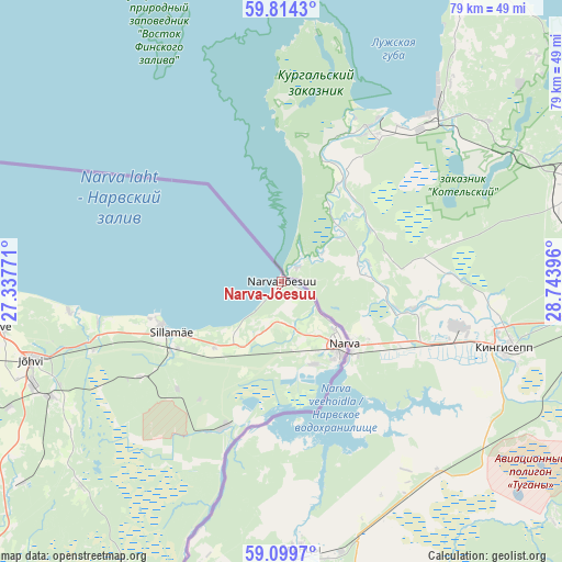
59° 27' 32.004" North, 28° 2' 26.988" East
| Map corner | latitude | longitude |
|---|---|---|
| Upper-left | 59.8143°, | 27.33771° |
| Center: | 59.45889°, | 28.04083° |
| Lower-right: | 59.0997°, | 28.74396° |
| Map W x H: | 79.5×79.5 km | = 49.4×49.4mi |
| max Lat: | 59.57639° ⇑6.8% North |
| Narva-Jõesuu: | 59.45889° |
| min Lat: | ⇓93.2% South 57.72778° |
| min Long | Narva-Jõesuu | max Long |
| 22.24646° | 28.04083° | 28.19028° |
| W 98.9%⇐ | ⇒1.1% E |
Elevation
Elevation of Narva-Jõesuu is 14 m = 46 ft, and this is 39.2 m = 129 ft below average elevation for this country.
| Max E: |
141 m = 463 ft | 87.9% |
| Avg. | 53.2 m = 175 ft | |
| Narva-Jõesuu | 14 m = 46 ft | |
Min E: |
6 m = 20 ft | 12.1% |
See also: Estonia elevation on elevation.city.
Geographical zone
Narva-Jõesuu is located in North temperate zone (between Tropic of Cancer and the Arctic Circle). Distance of this North polar circle is 790 km =490.9 mi to North.| Distance of | km | miles | from Narva-Jõesuu |
|---|---|---|---|
| North Pole | 3395.9 | 2110.1 | to North |
| Arctic Circle | 790 | 490.9 | to North |
| Tropic Cancer | 4005.3 | 2488.8 | to South |
| Equator | 6611.2 | 4108 | to South |


Nearby cities:
15 places around Narva-Jõesuu: (largest is in red/bold)
• Aseri
66.3 km =41.2 mi,  269°
269°
• Iisaku
57.6 km =35.8 mi,  226°
226°
• Järve
41.7 km =25.9 mi,  261°
261°
• Jõhvi
36.8 km =22.9 mi,  252°
252°
• Kiviõli
61.7 km =38.3 mi, 258°
• Kohtla-Järve
43.9 km =27.3 mi, 261°
• Kohtla-Nõmme
50.4 km =31.3 mi, 256°
• Mäetaguse
50.5 km =31.4 mi,  239°
239°
• Narva
12.4 km =7.7 mi,  137°
137°
• Olgina
8.5 km =5.3 mi,  145°
145°
• Püssi
57.1 km =35.5 mi, 258°
• Sillamäe
17.1 km =10.6 mi, 246°
• Sonda
69.4 km =43.1 mi, 259°
• Toila
30.4 km =18.9 mi, 262°
• Voka
26.5 km =16.5 mi, 257°
Sources, notices
• [Note1] Compared only with cities in Estonia existing in our database
• [Src1] Map data: © OpenStreetMap contributors (CC-BY-SA)
• [Src2] Other city data from geonames.org with taken over terms of usage.
• [Src3] Geographical zone / Annual Mean Temperature by Robert A. Rohde @ Wikipedia
