Värska geodata
Värska (Võrumaa) is a seat of a second-order administrative division; located in Estonia in Europe/Tallinn (GMT+3) time zone. With population of 563 people, there are 149 cities with bigger population in this country. Compared to other cities in Estonia, 94.2% of cities are located further ↑North; 97.9% of cities are located further ←West and 61.6% of cities have higher elevation than Värska. Note1


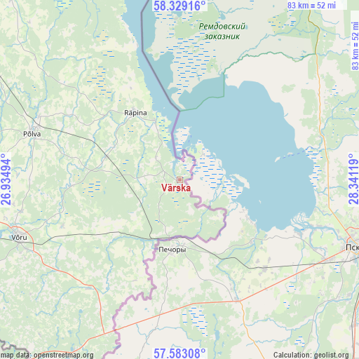
Värska GPS coordinates[2]
57° 57' 29.016" North, 27° 38' 17.016" East
| Map corner | latitude | longitude |
|---|---|---|
| Upper-left | 58.32916°, | 26.93494° |
| Center: | 57.95806°, | 27.63806° |
| Lower-right: | 57.58308°, | 28.34119° |
| Map W x H: | 83×83 km | = 51.6×51.6mi |
| max Lat: | 59.57639° ⇑94.2% North |
| Värska: | 57.95806° |
| min Lat: | ⇓5.8% South 57.72778° |
| min Long | Värska | max Long |
| 22.24646° | 27.63806° | 28.19028° |
| W 97.9%⇐ | ⇒2.1% E |
Elevation
Elevation of Värska is 46 m = 151 ft, and this is 7.2 m = 24 ft below average elevation for this country.
| Max E: |
141 m = 463 ft | 61.6% |
| Avg. | 53.2 m = 175 ft | |
| Värska | 46 m = 151 ft | |
Min E: |
6 m = 20 ft | 38.4% |
See also: Estonia elevation on elevation.city.
Geographical zone
Värska is located in North temperate zone (between Tropic of Cancer and the Arctic Circle). Distance of this North polar circle is 956.8 km =594.5 mi to North.| Distance of | km | miles | from Värska |
|---|---|---|---|
| North Pole | 3562.7 | 2213.8 | to North |
| Arctic Circle | 956.8 | 594.5 | to North |
| Tropic Cancer | 3838.4 | 2385.1 | to South |
| Equator | 6444.3 | 4004.3 | to South |


Nearby cities:
15 places around Värska: (largest is in red/bold)
• Ahja
43 km =26.7 mi,  309°
309°
• Himmaste
35.7 km =22.2 mi,  291°
291°
• Kanepi
52.1 km =32.4 mi,  273°
273°
• Kose
39 km =24.2 mi,  245°
245°
• Mammaste
36.9 km =22.9 mi, 289°
• Parksepa
39 km =24.2 mi,  262°
262°
• Põlva
35.4 km =22 mi, 288°
• Räpina
18.6 km =11.6 mi,  326°
326°
• Rõuge
50.1 km =31.1 mi,  239°
239°
• Vastse-Kuuste
47.8 km =29.7 mi,  299°
299°
• Vastseliina
32.6 km =20.3 mi,  218°
218°
• Veriora
17.6 km =10.9 mi, 286°
• Väimela
37.3 km =23.2 mi, 258°
• Võnnu
49.7 km =30.9 mi,  315°
315°
• Võru
39.1 km =24.3 mi, 249°
Sources, notices
• [Note1] Compared only with cities in Estonia existing in our database
• [Src1] Map data: © OpenStreetMap contributors (CC-BY-SA)
• [Src2] Other city data from geonames.org with taken over terms of usage.
• [Src3] Geographical zone / Annual Mean Temperature by Robert A. Rohde @ Wikipedia
