Parksepa geodata
Parksepa (Võrumaa) is a populated place; located in Estonia in Europe/Tallinn (GMT+3) time zone. With population of 737 people, there are 120 cities with bigger population in this country. Compared to other cities in Estonia, 94.7% of cities are located further ↑North; 85.3% of cities are located further ←West and 85.8% of cities have lower elevation than Parksepa. Note1


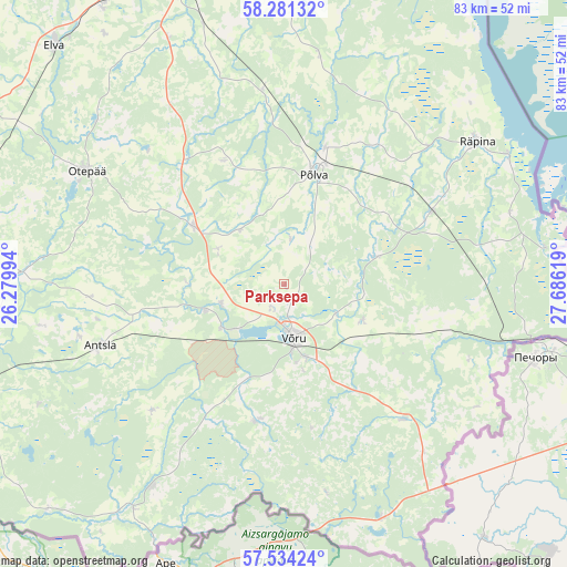
Parksepa GPS coordinates[2]
57° 54' 34.992" North, 26° 58' 59.016" East
| Map corner | latitude | longitude |
|---|---|---|
| Upper-left | 58.28132°, | 26.27994° |
| Center: | 57.90972°, | 26.98306° |
| Lower-right: | 57.53424°, | 27.68619° |
| Map W x H: | 83.1×83.1 km | = 51.6×51.6mi |
| max Lat: | 59.57639° ⇑94.7% North |
| Parksepa: | 57.90972° |
| min Lat: | ⇓5.3% South 57.72778° |
| min Long | Parksepa | max Long |
| 22.24646° | 26.98306° | 28.19028° |
| W 85.3%⇐ | ⇒14.7% E |
Elevation
Elevation of Parksepa is 83 m = 272 ft, and this is 29.8 m = 98 ft above average elevation for this country.
| Max E: |
141 m = 463 ft | 14.2% |
| Parksepa | 83 m 272 ft | |
| Avg. | 53.2 m = 175 ft | |
Min E: |
6 m = 20 ft | 85.8% |
See also: Estonia elevation on elevation.city.
Geographical zone
Parksepa is located in North temperate zone (between Tropic of Cancer and the Arctic Circle). Distance of this North polar circle is 962.2 km =597.9 mi to North.| Distance of | km | miles | from Parksepa |
|---|---|---|---|
| North Pole | 3568.1 | 2217.1 | to North |
| Arctic Circle | 962.2 | 597.9 | to North |
| Tropic Cancer | 3833 | 2381.7 | to South |
| Equator | 6439 | 4001 | to South |


Nearby cities:
15 places around Parksepa: (largest is in red/bold)
• Ahja
33.1 km =20.6 mi,  9°
9°
• Antsla
27.8 km =17.3 mi,  250°
250°
• Himmaste
19.4 km =12.1 mi,  16°
16°
• Kanepi
15.7 km =9.8 mi,  301°
301°
• Kose
11.2 km =7 mi,  163°
163°
• Mammaste
17.8 km =11.1 mi, 11°
• Põlva
17.5 km =10.9 mi, 16°
• Räpina
35.2 km =21.9 mi,  53°
53°
• Rõuge
20.7 km =12.9 mi,  192°
192°
• Vana-Antsla
27.1 km =16.8 mi,  259°
259°
• Vastse-Kuuste
28.9 km =18 mi,  353°
353°
• Vastseliina
27.2 km =16.9 mi,  137°
137°
• Veriora
24.2 km =15 mi,  64°
64°
• Väimela
3 km =1.9 mi,  134°
134°
• Võru
8.7 km =5.4 mi,  165°
165°
Sources, notices
• [Note1] Compared only with cities in Estonia existing in our database
• [Src1] Map data: © OpenStreetMap contributors (CC-BY-SA)
• [Src2] Other city data from geonames.org with taken over terms of usage.
• [Src3] Geographical zone / Annual Mean Temperature by Robert A. Rohde @ Wikipedia
