Võru geodata
Võru (Võrumaa) is a seat of a first-order administrative division; located in Estonia in Europe/Tallinn (GMT+3) time zone. With population of 14,631 people, there are 10 cities with bigger population in this country. Compared to other cities in Estonia, 96.8% of cities are located further ↑North; 86.3% of cities are located further ←West and 79.5% of cities have lower elevation than Võru. Note1


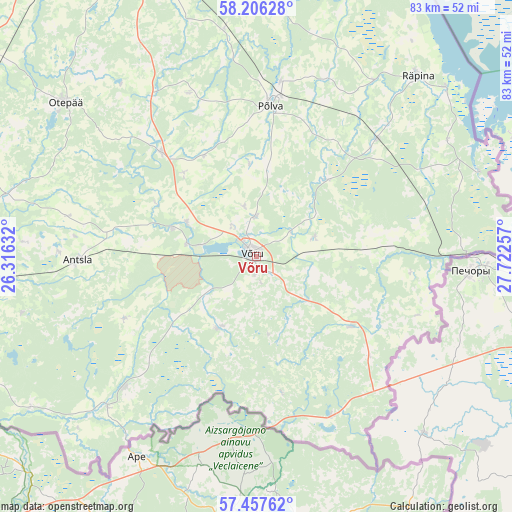
Võru GPS coordinates[2]
57° 50' 2.004" North, 27° 1' 9.984" East
| Map corner | latitude | longitude |
|---|---|---|
| Upper-left | 58.20628°, | 26.31632° |
| Center: | 57.83389°, | 27.01944° |
| Lower-right: | 57.45762°, | 27.72257° |
| Map W x H: | 83.2×83.2 km | = 51.7×51.7mi |
| max Lat: | 59.57639° ⇑96.8% North |
| Võru: | 57.83389° |
| min Lat: | ⇓3.2% South 57.72778° |
| min Long | Võru | max Long |
| 22.24646° | 27.01944° | 28.19028° |
| W 86.3%⇐ | ⇒13.7% E |
Elevation
Elevation of Võru is 76 m = 249 ft, and this is 22.8 m = 75 ft above average elevation for this country.
| Max E: |
141 m = 463 ft | 20.5% |
| Võru | 76 m 249 ft | |
| Avg. | 53.2 m = 175 ft | |
Min E: |
6 m = 20 ft | 79.5% |
See also: Estonia elevation on elevation.city.
Geographical zone
Võru is located in North temperate zone (between Tropic of Cancer and the Arctic Circle). Distance of this North polar circle is 970.6 km =603.1 mi to North.| Distance of | km | miles | from Võru |
|---|---|---|---|
| North Pole | 3576.5 | 2222.3 | to North |
| Arctic Circle | 970.6 | 603.1 | to North |
| Tropic Cancer | 3824.6 | 2376.5 | to South |
| Equator | 6430.5 | 3995.7 | to South |


Nearby cities:
15 places around Võru: (largest is in red/bold)
• Antsla
28.4 km =17.6 mi,  268°
268°
• Himmaste
27.2 km =16.9 mi,  6°
6°
• Kanepi
22.7 km =14.1 mi,  316°
316°
• Kose
2.6 km =1.6 mi,  156°
156°
• Mammaste
25.9 km =16.1 mi,  3°
3°
• Parksepa
8.7 km =5.4 mi,  345°
345°
• Põlva
25.3 km =15.7 mi, 6°
• Räpina
39.4 km =24.5 mi,  41°
41°
• Rõuge
13.5 km =8.4 mi,  208°
208°
• Vana-Antsla
29 km =18 mi,  277°
277°
• Vastse-Kuuste
37.5 km =23.3 mi, 351°
• Vastseliina
20 km =12.4 mi,  125°
125°
• Veriora
27.3 km =17 mi,  46°
46°
• Väimela
6.3 km =3.9 mi,  359°
359°
• Värska
39.1 km =24.3 mi,  69°
69°
Sources, notices
• [Note1] Compared only with cities in Estonia existing in our database
• [Src1] Map data: © OpenStreetMap contributors (CC-BY-SA)
• [Src2] Other city data from geonames.org with taken over terms of usage.
• [Src3] Geographical zone / Annual Mean Temperature by Robert A. Rohde @ Wikipedia
