Turba geodata
Turba (Harjumaa) is a populated place; located in Estonia in Europe/Tallinn (GMT+3) time zone. With population of 1,096 people, there are 76 cities with bigger population in this country. Compared to other cities in Estonia, 60% of cities are located further ↓South; 87.9% of cities are located further →East and 54.7% of cities have higher elevation than Turba. Note1


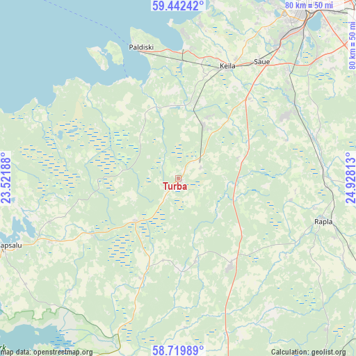
Turba GPS coordinates[2]
59° 4' 59.016" North, 24° 13' 30" East
| Map corner | latitude | longitude |
|---|---|---|
| Upper-left | 59.44242°, | 23.52188° |
| Center: | 59.08306°, | 24.225° |
| Lower-right: | 58.71989°, | 24.92813° |
| Map W x H: | 80.3×80.3 km | = 49.9×49.9mi |
| max Lat: | 59.57639° ⇑40% North |
| Turba: | 59.08306° |
| min Lat: | ⇓60% South 57.72778° |
| min Long | Turba | max Long |
| 22.24646° | 24.225° | 28.19028° |
| W 12.1%⇐ | ⇒87.9% E |
Elevation
Elevation of Turba is 51 m = 167 ft, and this is 2.2 m = 7 ft below average elevation for this country.
| Max E: |
141 m = 463 ft | 54.7% |
| Avg. | 53.2 m = 175 ft | |
| Turba | 51 m = 167 ft | |
Min E: |
6 m = 20 ft | 45.3% |
See also: Estonia elevation on elevation.city.
Geographical zone
Turba is located in North temperate zone (between Tropic of Cancer and the Arctic Circle). Distance of this North polar circle is 831.8 km =516.9 mi to North.| Distance of | km | miles | from Turba |
|---|---|---|---|
| North Pole | 3437.6 | 2136 | to North |
| Arctic Circle | 831.8 | 516.9 | to North |
| Tropic Cancer | 3963.5 | 2462.8 | to South |
| Equator | 6569.4 | 4082 | to South |


Nearby cities:
15 places around Turba: (largest is in red/bold)
• Alu
31.4 km =19.5 mi,  102°
102°
• Harku
10 km =6.2 mi,  56°
56°
• Keila
26.8 km =16.7 mi,  23°
23°
• Kiisa
31.5 km =19.6 mi, 57°
• Klooga
26.3 km =16.3 mi,  358°
358°
• Kohila
31.8 km =19.8 mi,  72°
72°
• Lehola
23.8 km =14.8 mi,  11°
11°
• Märjamaa
23.1 km =14.4 mi,  149°
149°
• Orgita
20.8 km =12.9 mi, 145°
• Paldiski
32 km =19.9 mi,  342°
342°
• Palivere
22.3 km =13.9 mi,  235°
235°
• Riisipere
6 km =3.7 mi,  54°
54°
• Taebla
30.6 km =19 mi, 242°
• Vasalemma
18.3 km =11.4 mi, 11°
• Ääsmäe
24.1 km =15 mi,  43°
43°
Sources, notices
• [Note1] Compared only with cities in Estonia existing in our database
• [Src1] Map data: © OpenStreetMap contributors (CC-BY-SA)
• [Src2] Other city data from geonames.org with taken over terms of usage.
• [Src3] Geographical zone / Annual Mean Temperature by Robert A. Rohde @ Wikipedia
